

Cold front bringing rain, storms to Tampa Bay area before temps drop. Here's what to expect
Tampa weather | Wednesday forecast
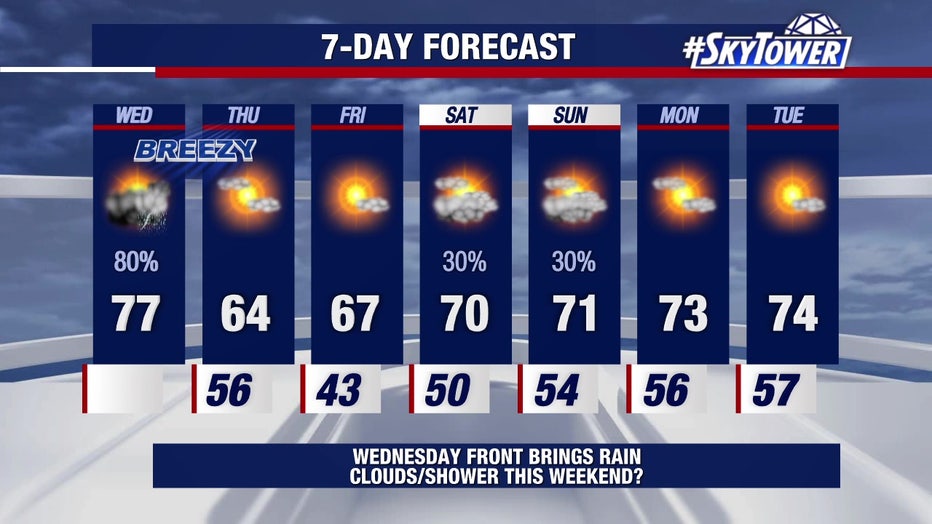
FOX 13 Meteorologist Dave Osterberg says Wednesday will be breezy and mild before a cold front brings rain and storms in the afternoon. Temperatures will drop by Thursday with the afternoon high only reaching the mid-60s. Friday morning will be chilly with 30s and 40s in the Bay Area.
TAMPA, Fla. - A cold front is moving into Florida on Wednesday, bringing rain and storms to the Tampa Bay area before temperatures drop.
Wednesday forecast
Timeline:
FOX 13 Meteorologist Dave Osterberg says conditions will be breezy and humid with the afternoon high climbing into the mid-70s before the front arrives.
Rain should start moving through the region around 3 p.m., according to Osterberg, shifting east through the late afternoon and evening hours.
"There could be some rumbles of thunder, but we're not anticipating any severe weather," Osterberg said, adding that total rainfall will likely range from half-an-inch to an inch in most spots.
The line of rain should be out of the area entirely by about 9 or 10 p.m., Osterberg says.
Lower temperatures ahead
By the numbers:
Once the rain is gone, Osterberg says a north wind will take over, dropping the afternoon high into the mid-60s for Thursday with much lower humidity.
Friday will be our coldest morning during this stretch, with lows in the 40s across much of the Bay Area and 30s to the north.
Temperatures will drop on Thursday and Friday before a gradual warmup starts this weekend.
Temperatures will be slightly warmer this weekend, with highs around 70 degrees and a chance of showers late Saturday into Sunday.
STAY CONNECTED WITH FOX 13 TAMPA:
- Download the FOX Local app for your smart TV
- Download FOX Local mobile app: Apple | Android
- Download the FOX 13 News app for breaking news alerts, latest headlines
- Download the SkyTower Radar app
- Sign up for FOX 13’s daily newsletter