Hurricane Helene timeline: Here’s what to expect

Hurricane Helene becomes Cat 2 storm
FOX 13 News Meteorologist Dave Osterberg says tornadoes can pop up in Helene's outer bands.
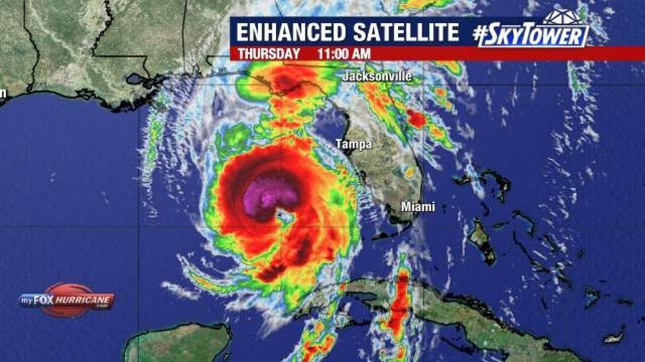
TAMPA, Fla. - Hurricane Helene formed late Wednesday morning, and is expected to rapidly intensify before making landfall in the Big Bend area on Thursday.
While it looks like the Bay Area will be spared a direct hit, we will be impacted by heavy rain, wind and storm surge.
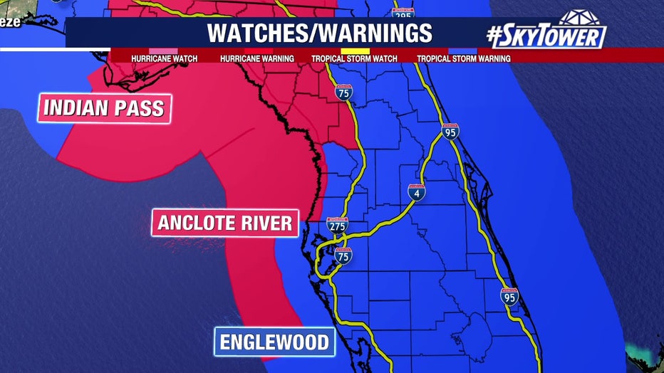
A hurricane warning is in effect for Anclote River to Mexico Beach and a hurricane watch is in effect for Englewood to Anclote River, including Tampa Bay.
How strong will Helene get?
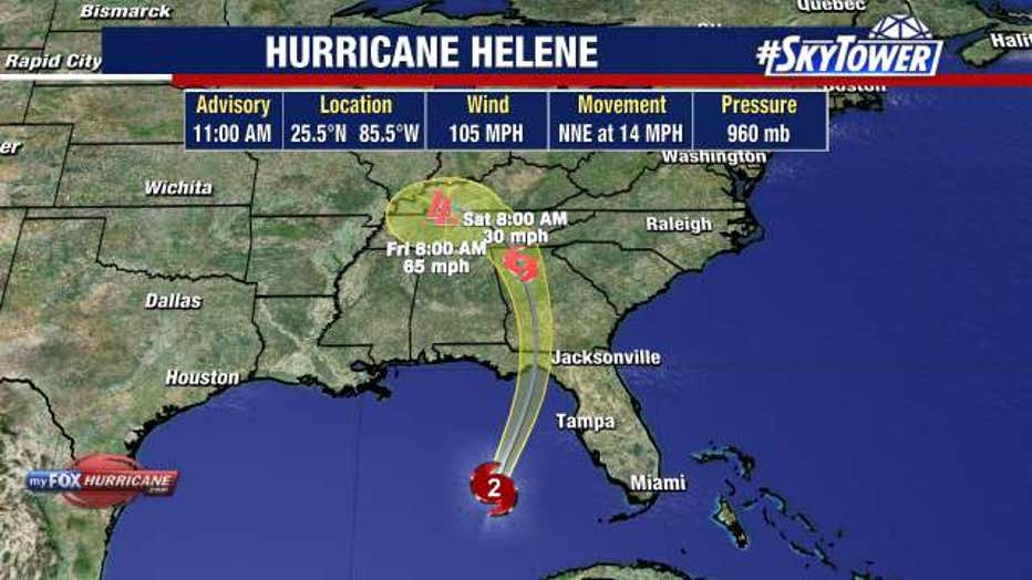
As of 8 a.m. on Thursday, Helene was located at 24.5 N and 85.9 W, had maximum sustained winds of 100 miles an hour and was moving north-northeast at 12 miles an hour.
READ: Hurricane Helene: County-by-county guide
FOX 13 Meteorologists say it will rapidly intensify as it passes along the west coast of Florida on Thursday, strengthening into a Category 4 hurricane with winds of 130 miles per hour.

When will Helene make landfall?
Hurricane Helene is expected to make landfall south of Tallahassee on Thursday night as a ‘major hurricane.’
READ: Hurricane Helene prompts evacuations in Bay Area
By Friday at 8 a.m., Helene’s winds should drop to about 60 miles an hour as it passes over Georgia. As it moves over inland Georgia, Helene will quickly weaken, and its winds will be about 25 miles an hour by 8 a.m. on Saturday.

When will Hurricane Helene impact the Bay Area?
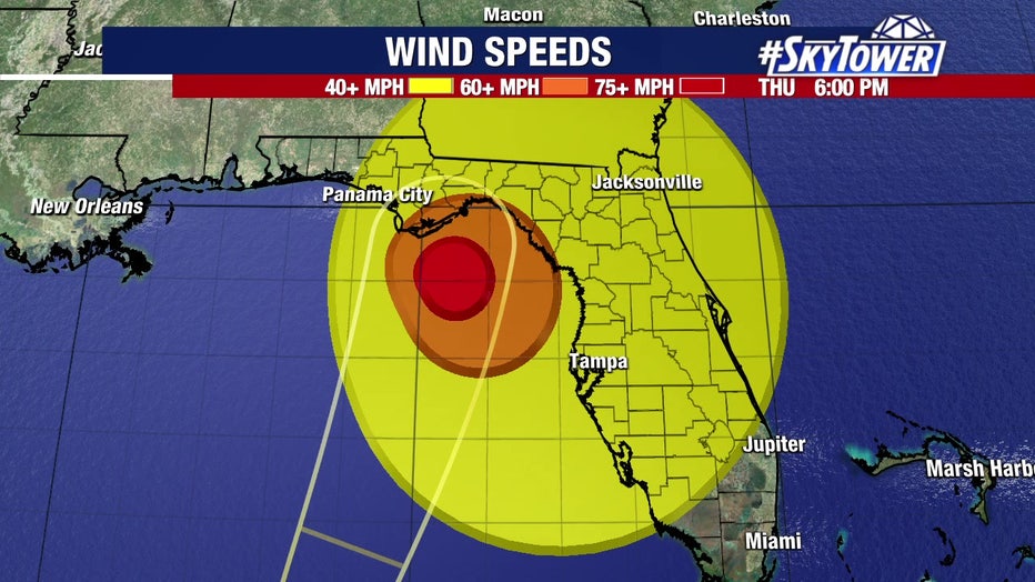
The tropical storm-force winds stretch up to 345 miles from the storm, something FOX 13 Meteorologist Dave Osterberg said is "unheard of."
READ: Hurricane Helene: Here's what's closed in the Bay Area
Wind gusts will be strong along the coast on Thursday afternoon, with tropical storm force winds extending statewide by about 3 p.m. Wind will continue to be an issue through the evening, especially closer to the coast where gusts could top 70 miles an hour.

A Tropical Storm Warning is in effect for:
- Florida Keys, including the Dry Tortugas
- Flamingo to Anclote River, including Tampa Bay
- West of Mexico Beach to the Okaloosa/Walton County Line
- Flamingo northward to South Santee River
- Lake Okeechobee
- Rio Lagartos to Cabo Catoche, Mexico
- Cuban provinces of Artemisa, Pinar del Rio, and the Isle of Youth
The Tropical Storm Watch north of South Santee River to Little River Inlet was upgraded to a Tropical Storm Warning at 5 p.m. on Wednesday.

As Helene passes by the Bay Area on Thursday afternoon, its winds will turn toward the south and southwest. That’s what will pile the water along the coastline and create a storm surge.
Pinellas County and into Tampa Bay could see 5–8 feet of storm surge and 4–7 feet in Sarasota and Manatee Counties.
Pasco and Hernando Counties could see 6–10 feet of storm surge, while Citrus County could see 10–15 feet of storm surge pushing along the coastline, causing flooding.

A Storm Surge Warning is in effect for:
- Mexico Beach eastward and southward to Flamingo
- Tampa Bay
- Charlotte Harbor
A Storm Surge Watch is in effect for:
- West of Indian Pass to Mexico Beach
What to expect county-by-county on Thursday and into Friday
Hillsborough and Pinellas counties
- 50-70 MPH wind gusts
- 5-8 feet of storm surge
- Tornadoes
- 4-8 inches of rainfall
Citrus and Hernando counties
- 55-75 MPH wind gusts
- 6 – 15 feet of storm surge
- 5 – 10 inches of rainfall
Polk and Highland counties
- 35-50 MPH wind gusts
- 2 – 4 inches of rainfall
- Isolated tornadoes
Sarasota and Manatee counties
- 45 – 60 MPH wind gusts
- 4 -7 feet of storm surge
- 4 -8 inches of rainfall
STAY CONNECTED WITH FOX 13 TAMPA:
- Download the FOX Local app for your smart TV
- Download the FOX 13 News app for breaking news alerts, latest headlines
- Download the SkyTower Radar app
- Sign up for FOX 13’s daily newsletter

