

Hurricane Milton brings ‘damaging winds’ as Cat. 2 storm after Siesta Key landfall
Hurricane Milton makes landfall near Siesta Key
FOX 13 chief meteorologist Paul Dellegatto says Hurricane Milton made landfall near Siesta Key around 8:30 p.m. Wednesday.
TAMPA, Fla. - Hurricane Milton continues to bring "devastating rains and damaging winds" after the storm made landfall on Siesta Key on Wednesday night.
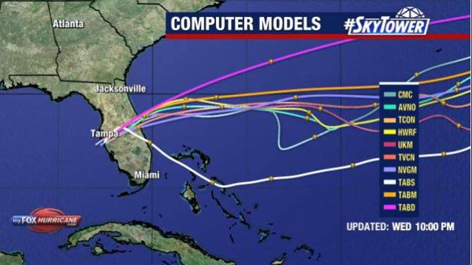
Milton remains a Category 2 hurricane as of 12 a.m. Thursday with maximum sustained winds of 100 miles per hour. Milton was right near the threshold of a major hurricane when it reached the west-central coast of Florida at around 8:30 p.m. Wednesday.
When it made landfall, Milton had maximum sustained winds of 120 miles per hour and was last reported moving east-northeast at 15 miles per hour. It's continuing to move east-northeast and is now located about 75 miles southwest of Orlando.

Hurricane Milton winds
Hurricane-force winds extend outward up to 35 miles from the center of Milton and tropical-storm-force winds extend outward up to 250 miles, especially to the north.
Hurricane force wind gusts will be felt across portions of the Tampa Bay area for hours late Wednesday into early Thursday, with tropical storm force winds extending across a large stretch of the state.
Governor Ron DeSantis declared a state of emergency for 51 Florida counties, while President Joe Biden has approved a federal disaster declaration ahead of Milton.
Watches and Warnings
A storm surge warning is in effect for Florida’s west coast from Flamingo northward to Yankeetown, including Charlotte Harbor and Tampa Bay, as well as the Sebastian Inlet, Florida to Altamaha Sound, Georgia, including the St. Johns River.
A hurricane warning is in effect for Florida’s west coast from Bonita Beach northward to Suwannee River, including Tampa Bay and on Florida’s east coast from the St. Lucie/Martin County Line northward to Ponte Vedra Beach.
Hurricane conditions are expected in the hurricane warning area across Florida beginning late Wednesday through early Thursday.
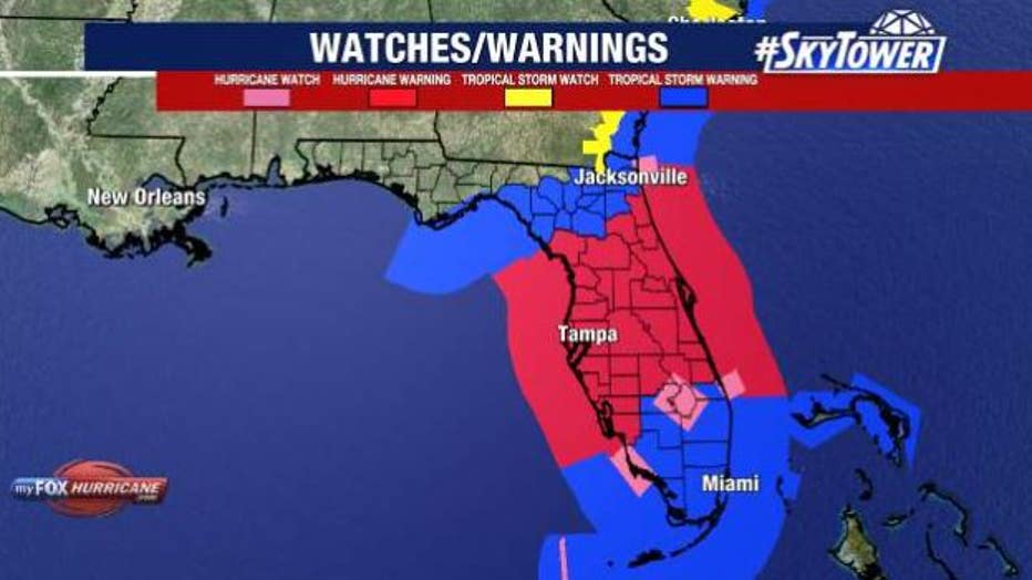
A tornado watch is in effect until 9 p.m. Wednesday for a portion of the Bay Area, including Hardee, Highlands, Hillsborough, Manatee, Pinellas, Polk and Sarasota counties. The tornado watch extends through all of South Florida.
Storm Surge
The National Hurricane Center says the combination of a dangerous storm surge and the tide will cause normally dry areas near the coast to be flooded by rising waters moving inland from the shoreline. The water could reach the following heights above ground somewhere in the indicated areas if the peak surge occurs at the time of high tide:
Anna Maria Island, FL to Boca Grande, FL - 9-13 ft
Anclote River, FL to Anna Maria Island, FL-6-9 ft
Tampa Bay-6-9 ft
Boca Grande, FL to Bonita Beach, FL-8-12 ft
Charlotte Harbor-8-12 ft
Bonita Beach, FL to Chokoloskee, FL-5-8 ft
Chokoloskee, FL to Flamingo, FL-3-5 ft
Sebastian Inlet, FL to Altamaha Sound, GA-3-5 ft
Yankeetown, FL to Anclote River, FL-2-4 ft
Dry Tortugas - 2-4 ft
St. Johns River - 2-4 ft
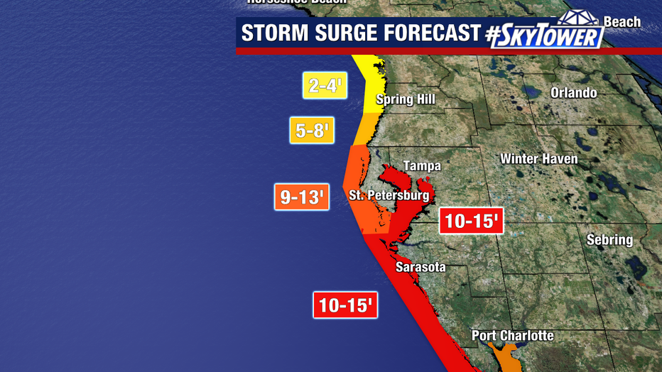
FOX 13 meteorologists say where Hurricane Milton makes landfall will make a huge difference in the amount of storm surge, with areas ranging from the eye to about 20–30 miles south getting the worst of it.
What is the difference between a watch and a warning?
A hurricane warning means that hurricane conditions are expected somewhere within the warning area. A warning is typically issued 36 hours before the anticipated first occurrence of tropical-storm-force winds, conditions that make outside preparations difficult or dangerous.
A hurricane watch means that hurricane conditions are possible within the watch area. A watch is typically issued 48 hours before the anticipated first occurrence of tropical-storm-force winds, conditions that make outside preparations difficult or dangerous.
Hurricane Milton: Mandatory evacuations in Tampa Bay Area
A storm surge warning means there is a danger of life-threatening inundation, from rising water moving inland from the coastline, during the next 36 hours in the indicated locations.
A storm surge watch means there is a possibility of life-threatening inundation, from rising water moving inland from the coastline, in the indicated locations during the next 48 hours.
How much rain will we get?
Florida can expect to see 6 – 12 inches of rain with some places getting up to 18 inches. The heaviest rain is expected north of the storm's center.
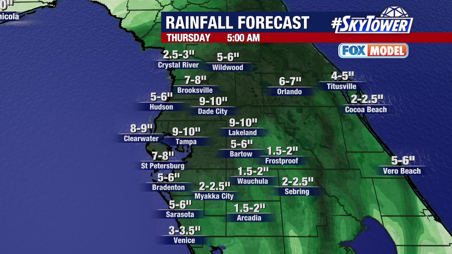
Hurricane Milton will bring heavy rain to Florida, especially north of the storm's center, leading to a risk of heavy flooding in some areas.
This rainfall brings the risk of catastrophic and life-threatening flash and urban flooding, along with moderate to major river flooding.
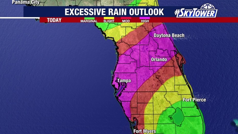
Hurricane Milton will bring heavy rain to parts of Florida, including the Tampa Bay area, Wednesday into Thursday.
STAY CONNECTED WITH FOX 13 TAMPA:
- Download the FOX Local app for your smart TV
- Download the FOX 13 News app for breaking news alerts, latest headlines
- Download the SkyTower Radar app
- Sign up for FOX 13’s daily newsletter