

Potential Tropical Cyclone Six forms, expected to become tropical storm on Monday
TAMPA, Fla. - Potential Tropical Cyclone Six, which had been known as Invest 91L. is likely to form into a tropical storm on Monday, according to the National Hurricane Center.

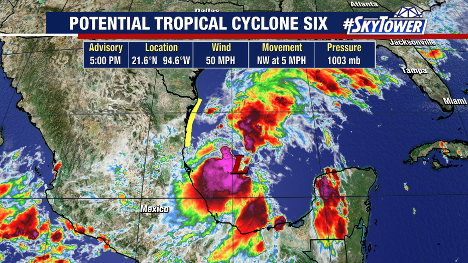
As of the 5 p.m. advisory from the NHC, Potential Tropical Cyclone Six is located more than 300 miles south-southeast of the mouth of the Rio Grande or less than 600 miles south of Port Arthur, Texas.
A Tropical Storm Watch has been issued along Mexico's Gulf Coast from Barra del Tordo northward to the mouth of the Rio Grande.
More watches or warnings may be issued later on Sunday night or Monday for parts of the Texas and Louisiana coastlines.
READ: Mote Marine documents impacts from Debby on Sarasota Bay
"It's Tuesday into Wednesday where, especially Southeast Texas and the coast of Louisiana, will start to see some tropical impacts," shared FOX 13 News Meteorologist Valerie Mills.
Mills says Florida will be on the outer edge of the system but the brunt of it will hit eastern Texas and Louisiana.
"All along these coastal spots and even heading inland, still some pretty big rain totals are going to be possible," explained Mills.
FOXWeather.com contributed to this story.
STAY CONNECTED WITH FOX 13 TAMPA:
- Download the FOX Local app for your smart TV
- Download the FOX 13 News app for breaking news alerts, latest headlines
- Download the SkyTower Radar app
- Sign up for FOX 13’s daily newsletter