Potential Tropical Cyclone 19 forms, likely to become Tropical Storm Sara and may impact Florida

Tampa weather | Light breeze and cooler temps
FOX 13 Chief Meteorologist Paul Dellegatto breaks down next week's possible track for Potential Tropical Cyclone Nineteen.
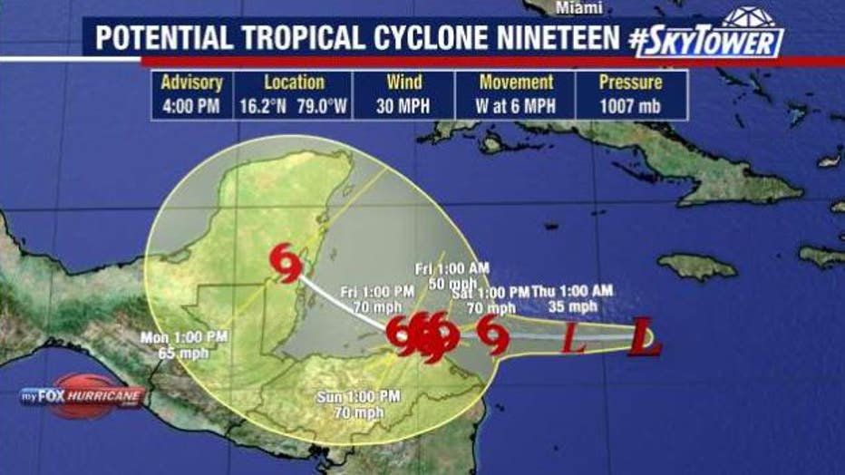
TAMPA, Fla. - Potential Tropical Cyclone 19 formed in the Caribbean on Wednesday afternoon and is expected to strengthen into Tropical Storm Sara on Thursday.
As of 4 p.m. on Wednesday, it was located at 16.2 N and 79.0 W. It had maximum sustained winds of 30 miles per hour and was moving west at six miles per hour.
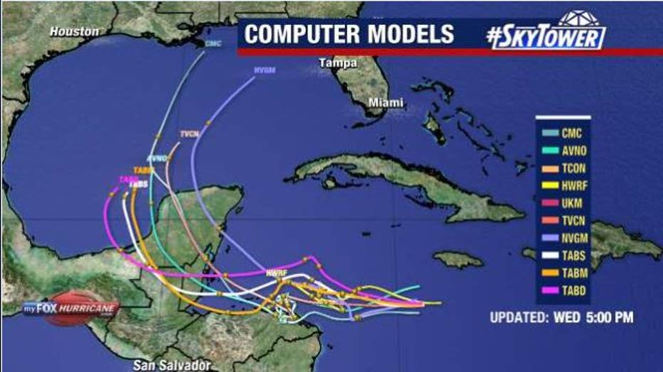
Some of those models show that the system, previously designated as Invest 99L on Tuesday, could continue to strengthen and become a hurricane. Hurricane Watches have been posted for parts of Honduras with Tropical Storm Watches in northern Nicaragua.
The NHC says Potential Tropical Cyclone 19 will continue to move westward toward the western Caribbean Sea, and Jamaica should see showers and thunderstorms associated with the system throughout the next day.
STAY CONNECTED: Download the free FOX 13 News app for Live SkyTower Radar, forecast videos, and more weather coverage
FOX 13 Chief Meteorologist Paul Dellegatto said the system will move very slowly to the west-northwest and get off the coast of Honduras, where it will likely cause flash flooding and mudslides.

Potential Tropical Cyclone 19 formed on Wednesday afternoon.
Where will Sara go?
Likely-Sara is forecast to meander around Central America through the weekend and into Mexico's Yucatán Peninsula into early next week.
After that, computer forecast models indicate that the system could restrengthen as it hangs out in the area and takes advantage of the warm waters and low wind shear.
From there, forecasters said an area of high pressure will build to the north of the system next week, and where it sets up will ultimately determine the path of future Sara.

Potential Tropical Cyclone 19 may impact Florida next week.
The steering currents may push the system into Central America or allow likely-Sara to move north and track into the Gulf of Mexico sometime next week – and could eventually impact Florida.
Dellegatto said it makes sense that Florida will see at least some impact from the storm. It may be a sloppy rain system or something stronger.
How strong will Sara become?
Sara's intensity will depend not only on water temperatures and wind shear, but also whether it moves over land before entering the Gulf of Mexico.
Dellegatto added that all the models on Wednesday showed a weaker storm than yesterday due to it likely spending more time over land than initially thought.
FOX Weather contributed to this report.
STAY CONNECTED WITH FOX 13 TAMPA BAY:
- Download the FOX Local app for your smart TV
- Download the FOX 13 News app for breaking news alerts, latest headlines
- Download the SkyTower Radar app
- Sign up for FOX 13’s daily newsletter

