

Is Milton's storm surge forecast for Tampa Bay worse than Helene's?
TAMPA, Fla. - A catastrophic storm surge is expected to inundate Florida's Gulf Coast from Hurricane Milton, raising water levels by up to 12 feet above ground level in areas of onshore winds.
The FOX Forecast Center warns of a likely record-breaking storm surge, potentially surpassing anything seen in over a century. This comes just weeks after Hurricane Helene caused significant damage along the state's coastline.
READ: Hurricane Milton tracker: Storm rapidly strengthens into strong Category 5
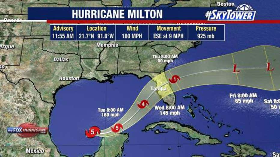
"The first storm surge forecast from the National Hurricane Center is out, and as feared, it's not good," FOX Weather Senior Weather Producer and Meteorologist Greg Diamond said. "8-12 feet if the surge comes in at high tide. During Helene, the storm surge around Tampa Bay was 7–8 feet."

This graphic shows the storm surge forecast from Hurricane Milton in Florida. (FOX Weather)
Massive waves will accompany the surge, exacerbating the flooding from Milton, which became a Category 5 hurricane on Monday and is expected to bring unprecedented flooding to the region, particularly around Tampa Bay.
READ: Hurricane Milton: County-by-county guide

This graphic shows the storm surge forecast from Hurricane Milton in Florida. (FOX Weather)
"Storm surge is the deadliest aspect of a hurricane," FOX Weather Meteorologist Craig Herrera said.
The FOX Forecast Center said the angle of approach will have the core of the storm moving perpendicular to the coastline. This track keeps everywhere south and east of it from the worst of the winds, which will push water rapidly onto the coastline.
Meteorologists often advise against focusing on the center line of the forecast cone, but in this case, the final landfall will play a huge role in who sees the worst storm surge. Every 10 miles up or down the coast will matter, the FOX Forecast Center said.
The NHC notes in its latest advisory Monday that the most severe flooding will occur near and south of the landfall location, where the surge will be accompanied by large, destructive waves. Due to the timing of the surge and tidal cycle, flooding can vary greatly over short distances.
Residents from Clearwater Beach to Fort Myers are urged to pay close attention to the forecast and be prepared for evacuation orders.
Storm Surge and Hurricane Watches have been issued for portions of Florida's west coast.
STAY CONNECTED WITH FOX 13 TAMPA:
- Download the FOX Local app for your smart TV
- Download the FOX 13 News app for breaking news alerts, latest headlines
- Download the SkyTower Radar app
- Sign up for FOX 13’s daily newsletter