

Saharan dust 2024: Here’s when it will impact Florida
TAMPA, Fla. - A massive plume of dust from Africa’s Saharan Desert is blowing across the entire Atlantic Ocean this week, set to reach the shores of Florida and Texas in the coming days and casting a haze over typically blue skies.
The plume is currently forecast to skirt South Florida late Friday night into early Saturday morning, then push into the Gulf of Mexico over the weekend.
On Friday, the Environmental Protection Commission of Hillsborough County issued air pollution precaution due to Saharan dust which is in effect throughout the weekend.
The EPA says unusually sensitive individuals, such as the elderly, children, and individuals with respiratory ailments may consider reducing prolonged or heavy exertion outdoors.
READ: Saharan dust headed toward Florida: Here's what it means for the tropics
Eventually, the plume is forecast to move into Southeast Texas from Sunday into Monday, with Corpus Christi and perhaps Houston likely to see some of the effects.
(FOX Weather)
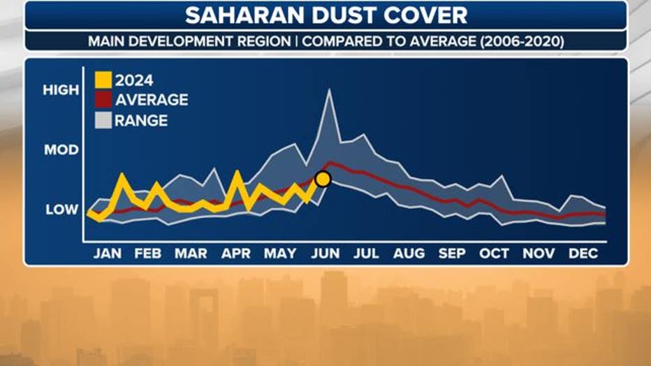
Coastal communities along the Florida Peninsula and the Gulf Coast are accustomed to seeing plumes of Saharan dust over the summer, which can impact air quality, produce colorful sunrises and sunsets, and reduce the chances of precipitation.
182 million tons of dust a year carried away from Africa
As daily triple-digit heat bakes the Saharan Desert, hot, dry air rises from the surface and carries fine particles of dust from the sands. That dust-laden air climbs to the highest reaches of the atmosphere, where winds called the Easterlies or Trade Winds (blowing from east to west) carry that dust about 3,000 miles across the Atlantic Ocean into the Western Hemisphere in what's known as the Saharan Air Layer (SAL).
PREVIOUS: Saharan Dust may cause allergy like symptoms and fuels red tide
According to NASA, about 182 million tons of dust leave Africa every year, though that amount can vary depending on the amount of rainfall south of the Sahara region.
(FOX Weather)
Depending on the amount of dust being carried by the plume, air quality can be drastically affected. This means that people who have certain types of breathing problems can experience difficulty. People in the path of the plume can also experience eye, nose and throat irritation because of the fine dust particles in the air, according to WebMD.
The dry air from the hot, sandy desert also works to suppress tropical development and significant plumes of dust and dry air are common in the Atlantic during the first two and a half months of the hurricane season.
FOX Weather)
However, the current situation is a bit unusual in that there is quite a bit of tropical activity percolating in the Atlantic even with a significant dust layer.
Invest 95L and another tropical disturbance just to its east are holding positions just south of the dust layer, and are feeding off available moisture to their south to skirt the edges of the dust layer as they trek west.
However, the dust layer may become an important variable in the storms’ future development depending on their track.
Saharan dust usually impacts the Bay Area each year during the summer months and continues until mid to late July.
Read more at FOXWeather.com.
SIGN UP: Click here to sign up for the FOX 13 daily newsletter