

Tropical Storm Debby strengthens, storm surge warnings in effect for Big Bend region of Florida
Tropical Storm Debby slightly strengthens
FOX 13 chief meteorologist Paul Dellegatto has the latest on Tropical Storm Debby.
TAMPA - Tropical Storm Debby has formed in the Gulf of Mexico as the focus on its trajectory toward Florida's Big Bend region grows.
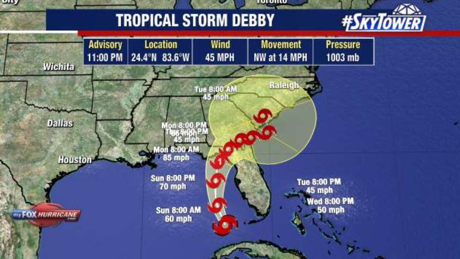
As of 11 p.m. Saturday, Tropical Storm Debby is located at 24.4 N 83.6 W with maximum sustained winds of 45 mph.
Most of Florida remains under a state of emergency, and administrators urge people to prepare now before the weather deteriorates during the second half of the weekend.
Intense tropical downpours are expected for portions of Florida and the coastal areas of the Southeast. As Debby intensifies, there is the potential for hurricane-force wind gusts of 74 mph across the state.
FOX 13 News Meteorologist Valerie Mills says the possibility of tornadoes in Tampa Bay can’t be ruled out.
Could this strengthen into a hurricane? It’s more likely with the latest track keeping it over the Gulf longer – but not certain. We can’t rule out rapid intensification over the incredibly warm waters, according to Mills.
As of 5 p.m. on Saturday, the National Hurricane Center expects Tropical Storm Debby to become a category 1 hurricane just before land fall.
Who is under tropical storm alerts?
The NHC says there are watches and warnings in the following areas:
A Hurricane Warning is in effect for:
- The Florida Gulf coast from the Suwannee River to the Ochlockonee River
A Hurricane Watch is in effect for:
- Florida coast west of the Ochlockonee River to Indian Pass
- Florida coast east of the Suwannee River to Yankeetown
A Tropical Storm Warning is in effect for:
- The Florida Keys west of the Seven Mile Bridge including the Dry Tortugas
- West coast of the Florida peninsula from south of the Suwannee River to East Cape Sable
A Tropical Storm Watch is in effect for:
- The Florida Keys north of the Seven Mile Bridge to the Channel 5 Bridge
- The Florida coast west of Indian Pass to Mexico Beach
A Storm Surge Warning is in effect for:
- Aripeka northward to Indian Pass
- A Storm Surge Watch is in effect for:
- Bonita Beach northward to Aripeka, including Tampa Bay and Charlotte Harbor
A Tropical Storm Warning means that tropical storm conditions are expected somewhere within the warning area within 36 hours.

Florida begins to prepare as flood threat increases
The FOX Forecast Center said showers and thunderstorms are already tearing off from the center of the storm and impacting southern portions of Florida.
The track has shifted west based on where the storm’s center of circulation is ending up on the southern edge of the island of Cuba. This will offer more time for it to strengthen over very warm Gulf waters.
Earlier interaction with land would cause the storm to weaken, but that looks less likely in the recent track, according to Mills. The west coast, and a large part of Florida, will get downpours, flooding and tropical-storm-force winds.
As the storm nears, rainfall will increase and spread from south to north across much of Florida through the weekend. Overall, rainfall total forecasts have increased to 5-10 inches with maximum totals up to 15 inches expected for portions of Florida and eventually up the southeastern U.S. coast.
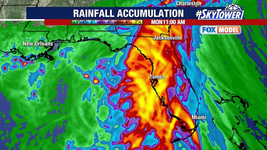
Those totals could bring both urban flooding and isolated river flooding, the NHC said.
Tropical storm-force winds are expected in the warned areas across southwestern Florida late Saturday into Saturday night, moving up the west coast of Florida into Sunday.
Storm surge of 2-5 feet is possible along portions of Florida's west coast, with the highest surge expected along the Big Bend area, and up to 4 feet in Tampa Bay and Charlotte Harbor, the NHC warned.
A Flood Watch is in effect for all of South Florida, including Miami, effective through Sunday evening.

Where does the storm go after landfall?
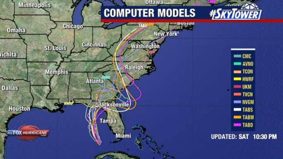
There still remains high uncertainty about the fate of the storm once it makes landfall on Monday. Weakening steering currents will cause the storm to slow down over northern Florida, and from there, forecast model guidance becomes split.
"We have this trough sitting to the north. Does it sink south enough to pick (the storm) up?" FOX Weather Meteorologist Britta Merwin said.
One scenario has the storm eventually getting scooped up by the passing trough to the north, which would pull the storm northeast along the Southeastern Coast of the U.S. but eventually race it up the Atlantic Seaboard where heavy rains wouldn't have quite as long to accumulate. Even then, several inches of rain would be forecast across the Southeast U.S. Coast.
But a second scenario shows the storm getting left behind and instead meandering around the Southeast Coast. Numerous forecast model solutions move the storm back over the warm Atlantic waters, and a potentially rejuvenated Debby would bring a dangerous mix of days of heavy rains, strong wind and even feet of storm surge along the coast of Georgia and the Carolinas, with a chance of a second land-falling tropical storm or hurricane.

"There’s a possibility that this storm stalls offshore and that’s really the worst case scenario, but that’s a worst case scenario that you need to be prepared for," Merwin said. "Any time you see a forecast (cone) that looks like a big old fishbowl, that means two things: a slowing storm or a stalled out storm. Both just equal a long duration of heavy rain, wind and unfortunately, if you have a storm stalling offshore, that means it could be strengthening and sitting offshore."
Either way, while Florida is in the sights of the storm first, those along the Southeast Coast need to be ready for a potentially impactful storm early next week.
Sandbagging stations open
Several Bay Area municipalities have opened sandbag locations ahead of the storm and Gov. Ron DeSantis declared a state of emergency on Thursday.
FOX Weather contributed to this story. Click here for more information from FOX Weather.
This is a developing story. Check back for updates.