

Tropical Depression 4 forms off Cuba’s coast, expected to become tropical storm as it nears Florida
TAMPA, Fla. - Potential Tropical Cyclone Four has been upgraded to Tropical Depression Four and portions of Florida are under a tropical storm watch or warning.
As of 11 p.m. Friday, Tropical Depression Four is located at 21.4 N and 79.7 W. after it formed off the South Coast of Cuba. It's now expected to become a tropical storm over the southeastern Gulf of Mexico by late Saturday, according to the National Hurricane Center.
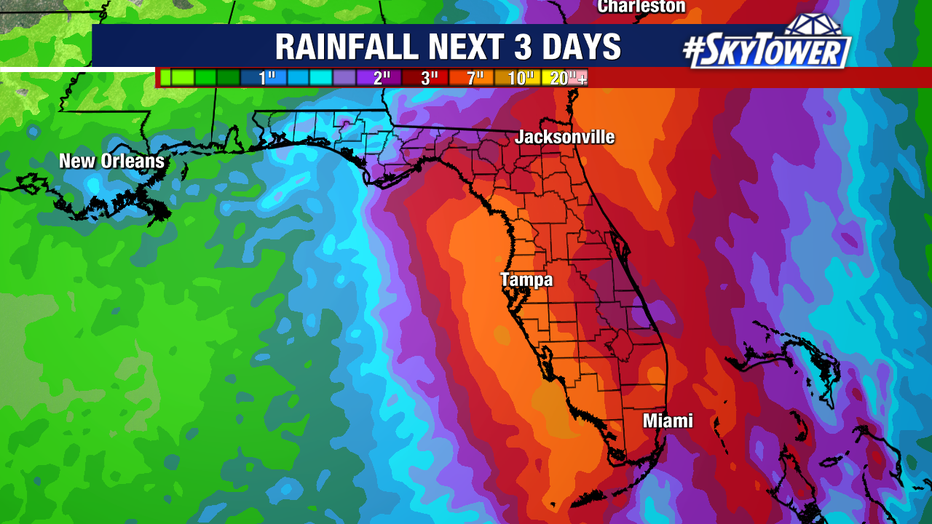
It is expected to bring tropical storm conditions and heavy rains to portions of Florida.
STAY CONNECTED: Download the free FOX 13 News app for Live SkyTower Radar, forecast videos, and more weather coverage
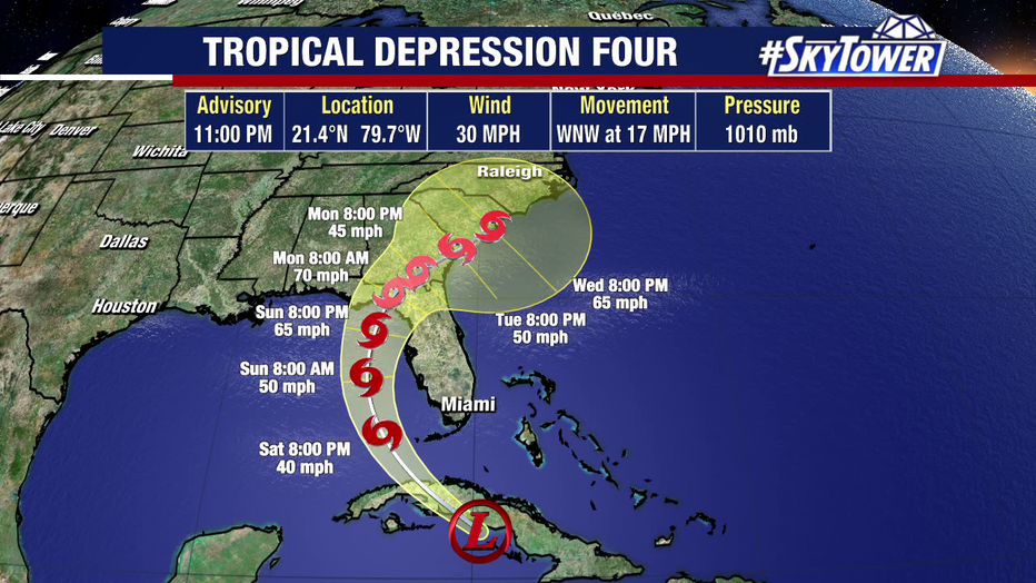
Tropical Depression Four has maximum sustained winds of 30 miles per hour and was moving west-northwest at 17 miles an hour.
When will we see tropical storm conditions?
According to the National Hurricane Center, Florida can expect to see tropical storm conditions beginning on Saturday night from Tropical Depression Four.
A Tropical Storm Warning has been extended northward along the west coast of Florida from Bonita Beach to Boca Grande.
A Tropical Storm Watch has been extended northward along the west coast of the Florida peninsula from Aripeka to the mouth of the Suwannee River.
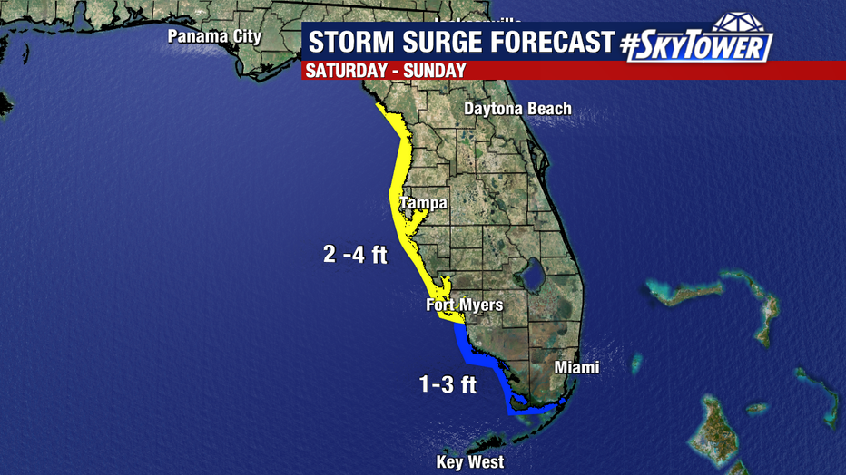
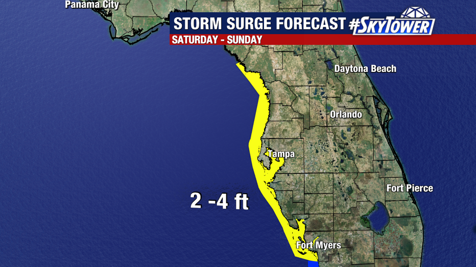
A Storm Surge Watch has been issued for the west coast of the Florida peninsula from Bonita Beach northward to the mouth of the Suwannee River, including Tampa Bay and Charlotte Harbor.
What is the difference between a Tropical Storm Warning and a Tropical Storm Watch?
A Tropical Storm Warning means that tropical storm conditions are expected somewhere within the warning area within 36 hours.
A Tropical Storm Watch means that tropical storm conditions are possible within the watch area, generally within 48 hours.
FOX 13 Meteorologist Valerie Mills says rain is going to be the biggest impact from this storm, with a general 4-6″ looking likely late Saturday through Sunday. A large portion of Florida is highlighted in a risk for excessive rain on Sunday, particularly central and southern FL.
Where and when will the storm make landfall?
Once it moves away from Cuba, the storm is expected to turn north and then northeast, crossing over the state of Florida. Mills says the storm is expected to move into the Atlantic early next week after it passes over the Sunshine State and exits near Jacksonville. She says the storm will then move into other southeastern states.
Mills says we will have to wait until after the storm passes Cuba to get a better idea of where it will make landfall.
She says it could skirt the west coast of Florida and make landfall potentially in the Big Bend area, or it could move further west and make landfall in the panhandle. It could also curve to the east earlier and make landfall on the west coast of the state, possibly anywhere from Fort Myers north.
Mills cautions that if it does skirt up the west coast of the state, the waters are very warm and there could be rapid intensification from Saturday into Sunday.
She expects the system to become a tropical low and possibly Tropical Storm Debby on Saturday as it moves into the Florida Straits. She does not expect it to happen while it is over Cuba because the island’s terrain will prevent it from strengthening.
According to Mills, the storm will likely make landfall somewhere between Fort Myers and the Big Bend area on Sunday.
The Bay Area can expect a deluge of rain from Saturday night and into Sunday. If it crosses south of Tampa Bay or north of Tampa Bay, the area will get several inches of rain.
The National Hurricane Center says coastal flooding is possible along Florida’s west coast throughout the weekend.
Several Bay Area municipalities have opened sandbag locations ahead of the storm and Governor Ron DeSantis declared a state of emergency on Thursday.
This is a developing story. Check back for updates.
SIGN UP: Click here to sign up for the FOX 13 daily newsletter