

Invest 91L now 'likely' to form tropical depression in Gulf of Mexico next week
PREVIOUS: Disturbance could become next tropical storm
FOX 13 News Meteorologist Valerie Mills says there are two area of interest in the Atlantic. One disturbance over the Bay of Campeche has a 40% chance of developing in the next two days and a 60% chance over the next week. Mills says the other area being monitored only has a 30% chance for development in the next seven days.
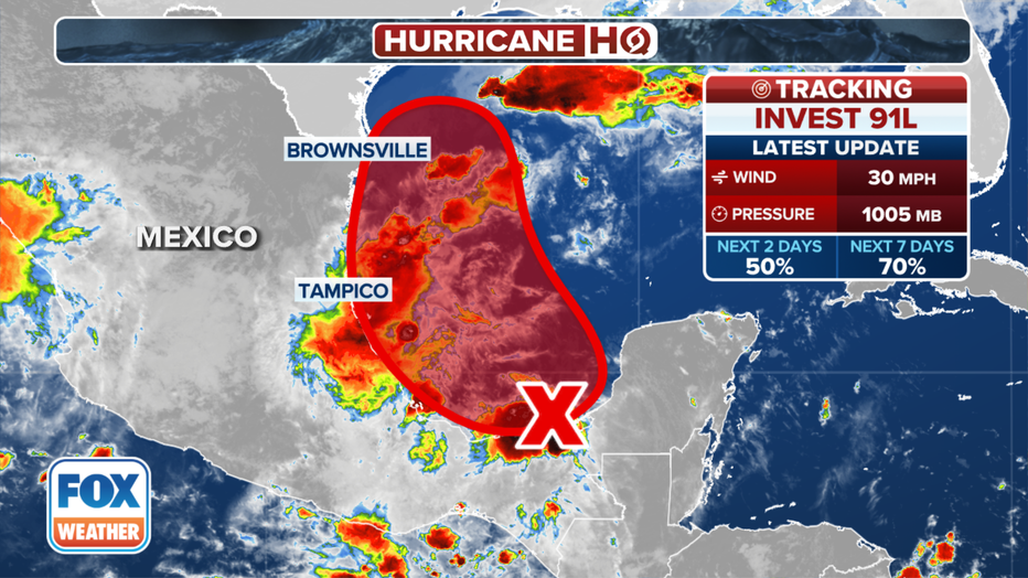
MIAMI - Odds are becoming more likely that a disturbance swirling around Mexico's Yucatan Peninsula this weekend will develop into at least a tropical depression if not Tropical Storm Francine as it moves into the Gulf of Mexico next week.
The National Hurricane Center (NHC) designated the system as Invest 91L earlier Saturday morning, which allows it to run additional computer models to calculate potential storm development and track.
The disturbance has spent more than a week making the journey across the Atlantic as a tropical wave, clinging to a disorganized cluster of showers and thunderstorms as it struggled to find conditions conducive for development.
This graphic shows the development chances of a tropical disturbance in the Caribbean Sea.(FOX Weather)
That remains the case as the disturbance currently sits near Belize and Mexico’s Yucatan Peninsula. But forecasts have the wave moving into the Bay of Campeche later Saturday where it is forecast to mix with two other ingredients to form into a more robust system.
"The tropical disturbance we tracked across the Caribbean this week is one of the ingredients," said FOX Weather Hurricane Specialist Bryan Norcross. "The northern flank of that system is moving into the extreme southern Gulf of Mexico. The non-tropical low-pressure system and its associated front, which together have been dousing Texas and Louisiana with heavy rain, are the second components. An approaching cold front that will move into the Gulf (Saturday) is the third."
The system is expected to pick up enough strength to become at least a tropical depression during the early to middle part of next week as it slides into the southwestern Gulf of Mexico.
"Winds are already forecast to be over 40 mph in the northern Gulf associated with the non-tropical low and the fronts, so there’s a good chance the system would jump right to Tropical Storm Francine if it develops," Norcross said.
The NHC has been steadily increasing the odds of development with each tropical forecast update, now giving the disturbance a 50% chance of development over the next two days, and a robust 70% chance over the next week — the highest rating it, or any other tropical system, has had in weeks.
"We could see a tropical depression form down (there), early to middle portions of next week. And then that could eventually become a threat to, say, somewhere along the western Gulf Coast," National Hurricane Center Director Dr. Michael Brennan told FOX Weather on Friday. "Pretty early to tell. But again, just a reminder, even though we've had a pretty long break here in the Atlantic, we've still been watching lots of systems. They just haven't had a really good chance of development. But this is sort of our best candidate at the moment."
Norcross says the system bears watching.
"Everybody near the coast in Louisiana and Texas should stay well-informed this week as we see how the three systems come together," he said.
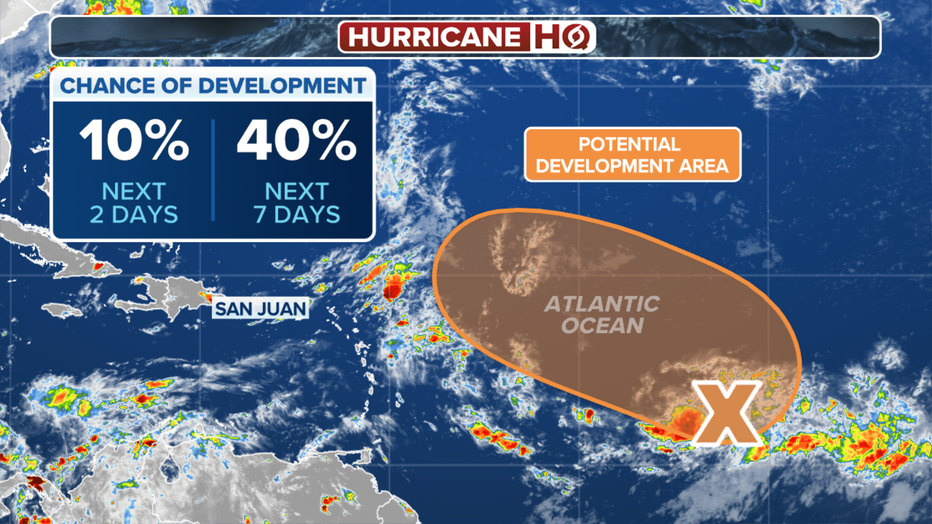
Another disturbance slowly gaining traction
A trough of low pressure that was barely clinging to tropical relevance in the central Atlantic has perked back up again, at least according to the long range development odds given by the NHC.
Tracking the tropics(FOX Weather)
The trough is currently just producing a broad area of showers and thunderstorms, but may become a more defined area of low pressure in the next few days, the NHC says.
The system is expected to meander in the middle of the ocean into early next week, but may find some better conditions for development as it drifts west-northwest into the middle and later part of next week.
The NHC has bumped up the odds of tropical development over the next week to 40 from 10%, placing the disturbance in the "medium" category.
"The system is currently forecast to be in the general vicinity of the northeastern Caribbean islands in about a week," Norcross said. "Stay tuned."
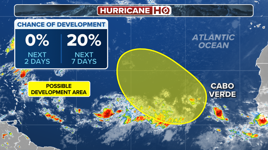
New third disturbance on the NHC radar
The NHC spent Friday erasing storms off their monitoring board, only to spend Saturday putting new ones back on. A third area to watch is now posted with a trough of low pressure located several hundred miles east-southeast of the Cabo Verde Islands, the NHC says.
Tracking the tropics(FOX Weather)
Some slow development is possible as it interacts with another wave coming off Africa next week. Right now, the NHC is sticking with low chances of development within the next seven days.
Read more at FOXWeather.com.