Caribbean Invest 99L could strengthen into Tropical Storm Sara and impact Florida
Caribbean disturbance could become Tropical Storm Sara
FOX 13 meteorologist Jim Weber is tracking the tropics with more on a disturbance that could become Tropical Storm Sara.
TAMPA, Fla. - There may be about three weeks left in the 2024 Hurricane Season, but the tropics are not slowing down.
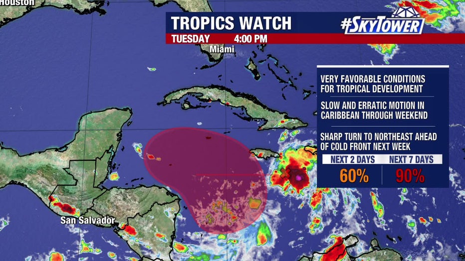
A disturbance in the Caribbean became Invest 99L on Tuesday and will likely become Tropical Storm Sara. FOX 13 Chief Meteorologist Paul Dellegatto says the tropical wave has a 90 percent chance of developing over the next week.
The "invest" designation allows NOAA forecasters to run specialized computer forecast models to get additional data on the disturbance's future growth potential.
On Tuesday, the NHC said the tropical wave was producing disorganized showers and thunderstorms.
However, FOX 13 Meteorologist Valerie Mills said the storms are looking more impressive in the central Caribbean along the tropical wave. It’s in an area that will allow for strengthening and a tropical depression is likely to form by Friday. Some of the computer models show the system becoming a hurricane by this weekend.

The tropics are still active despite there only being about 3 weeks left in the 2024 hurricane season.
Where will Sara go if it develops?
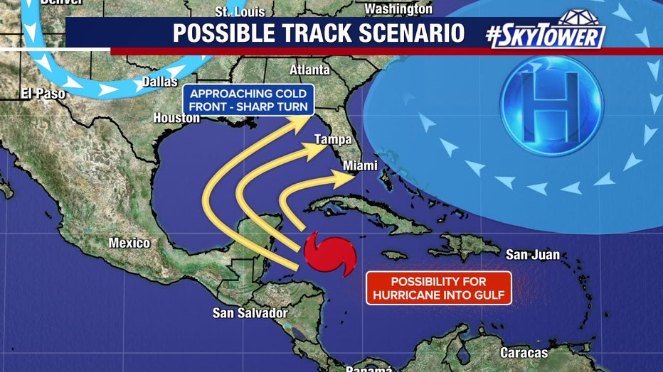
Dellegatto said it will become Tropical Storm Sara and is expected to have slow and erratic movement in the Caribbean. Eventually, when it tries to move north, Dellegatto says there will be a front headed south, which is typical for November.
He said as the front slides southeast, it will force Sara to make a big right-hand turn.
However, Dellegatto notes that where Sara makes landfall will depend on where it makes that right-hand turn. He said it could be down near Cuba, or over the Florida Straits, near the Bay Area, or in the Big Bend.

While it's too soon to tell where the system will go. It will likely take a sharp turn to the northeast ahead of a cold front next week.
Dellegatto says he tends to favor the models that have Sara making landfall somewhere in Southwest Florida.
He cautions that he is talking about something that is six or seven days away and things could change.
According to Dellegatto, there are a lot of stronger upper-level winds in November than in the summer, which can also impact where the storm goes and how strong it becomes.
Florida residents should keep a close eye on the forecast
A sharp dip in the jet stream and its accompanying cold front are forecast to reach Texas about a week from now.
"That strong jet stream dip could lift ‘likely-Sara’ out of the Caribbean around the middle of next week and accelerate it northeast toward Florida or east across the northern Caribbean," FOX Weather Hurricane Specialist Bryan Norcross said. "All possibilities are on the table."
He adds there are plausible scenarios indicating the storm could impact any part of the Florida Peninsula.
"Everyone from the Big Bend to South Florida and the Keys should stay up to date on the latest forecasts," he said. "Nothing will happen fast, but the computer forecasts are in unusually high agreement on the threat, so attention is required. On the current schedule, ‘likely-Sara’ would be in the vicinity of the Florida coast about Wednesday of next week."
But he reminds forecast watchers that predictions for systems that have yet to develop are subject to large errors and big changes.
"So don’t hang your hat on any one prediction," Norcross said. "Many possibilities are on the table, but be thinking about what you would do if action were required next week."
The Atlantic Hurricane Season officially ends Nov. 30.
FOX Weather contributed to this report. Click here to read more.
STAY CONNECTED WITH FOX 13 TAMPA BAY:
- Download the FOX Local app for your smart TV
- Download the FOX 13 News app for breaking news alerts, latest headlines
- Download the SkyTower Radar app
- Sign up for FOX 13’s daily newsletter

