Hurricane Milton rapidly intensifying, expected to hit Florida as major hurricane
Hurricane Milton gaining strength
FOX 13 chief meteorologist Paul Dellegatto and meteorologist Nash Rhodes have the very latest on Hurricane Milton.
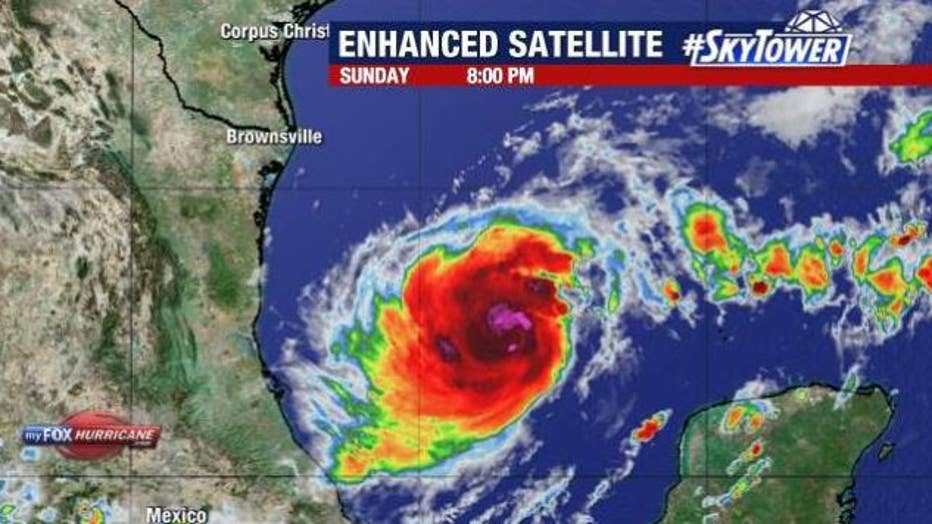
TAMPA, Fla. - Hurricane Milton continues to trek eastward across the Gulf of Mexico with an expected landfall Wednesday along Florida’s west coast.
As of 8 p.m. on Sunday, Hurricane Milton was located at 22.5 N and 93.4 W, which is about 780 miles west-southwest of Tampa.
It was a Category 1 hurricane with maximum sustained winds of 85 miles per hour and was moving east at seven miles an hour.
According to the National Hurricane Center, air force hurricane hunters found that Milton was "rapidly intensifying into a hurricane." The NHC says the risk of life-threatening impacts is increasing for parts of the Florida west coast.

When will Bay Area begin to feel the effects of Hurricane Milton?
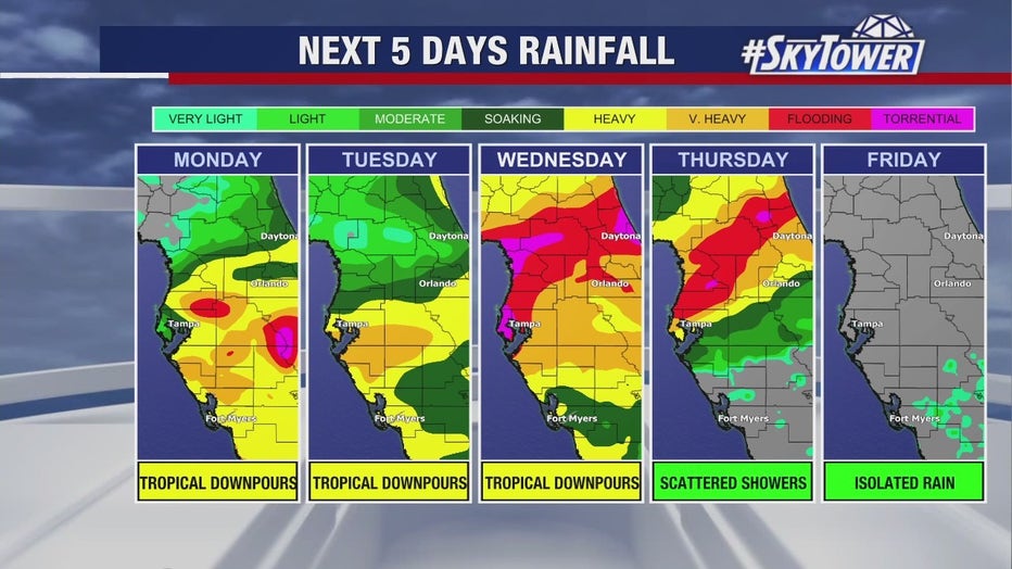
Areas of heavy rainfall will impact portions of Florida through Monday ahead of Milton, with heavy rainfall directly related to Milton from Tuesday through Wednesday night.
FOX 13 meteorologists are tracking Hurricane Milton and say weather models still disagree on where the storm will come on shore. However, it is expected to make landfall on Wednesday along Florida’s west coast.
They add that minor changes in landfall location will make a big difference to how the Bay Area will be impacted when it comes to storm surge and hurricane-force-winds.

FOX 13 Chief Meteorologist Paul Dellegatto says there will be a time when Milton rapidly intensifies and strengthens to a Category 4 or a Category 5 hurricane in the Gulf of Mexico.
However, Dellegatto believes Hurricane Milton will weaken as it encounters dry air and wind shear as it approaches our coastline. He cautions that while wind shear may weaken the storm, it may get bigger and the windfield may expand.
He noted that even if Hurricane Milton does weaken, it will not lessen the storm surge.
The landfall point is extremely important because the point of landfall south is going to be where the biggest storm surge is going to occur.
"The storm surge is going to be bad, "Dellegatto warns. "In some places, because of the path which is now perpendicular and not parallel to our coast, the storm surge could even be higher and probably will be higher in places. "
The National Hurricane Center expects storm surge and hurricane watches to be issued for portions of Florida early Monday.

How much rain is expected?
The heaviest rainfall is forecast to be from the I-4 corridor and southward, where a widespread area could see 5–8 inches of rainfall over the next week. Some areas may get almost a foot of rain.
Much of the rain will be spread out over several days, so widespread flooding is not expected, but issues could arise where thunderstorms repeatedly move over the same region.

Expected rainfall from Hurricane Milton.
STAY CONNECTED WITH FOX 13 TAMPA:
- Download the FOX Local app for your smart TV
- Download the FOX 13 News app for breaking news alerts, latest headlines
- Download the SkyTower Radar app
- Sign up for FOX 13’s daily newsletter

