Nicole reaches hurricane strength as it heads toward Florida
Hurricane Nicole approaches East Coast of Florida
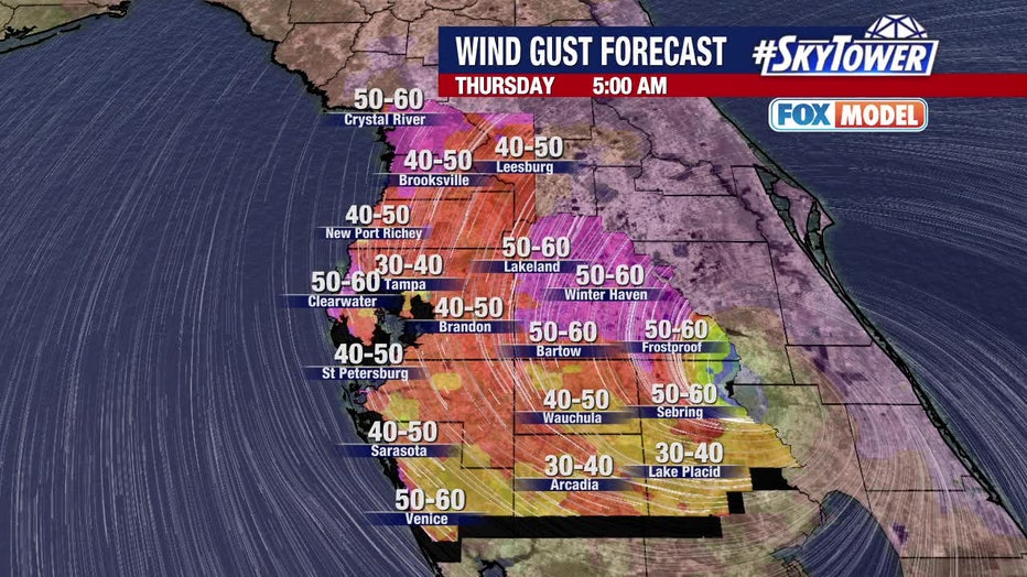
FOX 13 Chief Meteorologist Paul Dellegatto is keeping a close eye on Hurricane Nicole as it sets its sights on Florida. The entire Bay Area is under a tropical storm warning. Dellegatto says we can expect tropical storm-force winds, which will peak at 60 miles an hour and 2-4" of rain through Thursday. He says the worst weather for the Bay Area will be Thursday morning. As of Wednesday evening the center of the storm was over the Bahamas and Dellegatto predicts that landfall will be around 1 a.m. on the east coast of Florida.
TAMPA, Fla. - Tropical Storm Nicole strengthened into a category 1 hurricane Wednesday evening as it made landfall on Grand Bahama Island.
According to the National Hurricane Center, Hurricane Nicole has maximum sustained winds of 75 miles per hour with higher gusts. The massive storm's winds are already reaching the Tampa Bay region. It's expected to make landfall along the east coast late Wednesday into early Thursday morning.
A tropical storm warning is in effect for the Tampa Bay area and much of Florida's Gulf Coast as Nicole gradually gains strength while churning toward the state's Atlantic coastline. Just a few days ago, it did not look like a tropical storm, but it's becoming better organized.
"You’re really starting to see those waves pickup over on the eastern side of the state," explained FOX 13's meteorologist Jim Weber. "We’re seeing that storm surge and those really high waves are just relentless. This is going to continue for several more hours and into the day tomorrow as well."
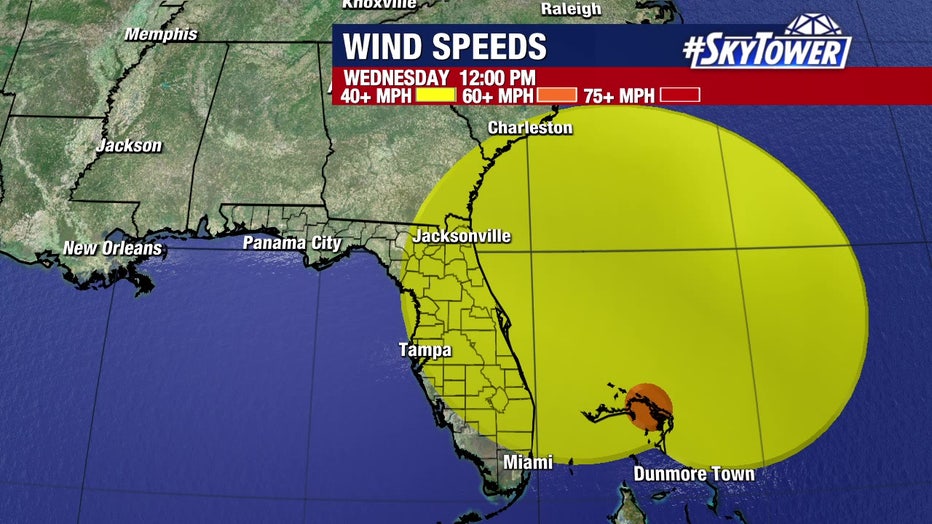
Weber said the size of the Nicole shows most of Florida will feel the impacts of the storm. Tropical-storm-force winds extend outward up to 460 miles.
"A lot of the time that cone of uncertainty is very misleading," he explained, "but, basically, we are talking essentially the entire state seeing at least tropical storm force winds."
In Florida, the St. Lucie County Sheriff’s Office said in a tweet that storm surge from Tropical Storm Nicole had already breached the sea wall along Indian River Drive, which runs parallel to the Atlantic Ocean. The Martin County Sheriff’s office also said seawater had breached part of a road on Hutchinson Island.
Florida yards washed into Atlantic Ocean before Nicole landfall
Storm surge from Tropical Storm Nicole began impacting the east coast of Florida, Video shows yards along the beach were washed away. This footage was captured by Krista Dowling Goodrich, who operates Salty Dog Vacations in Daytona Beach Shores.
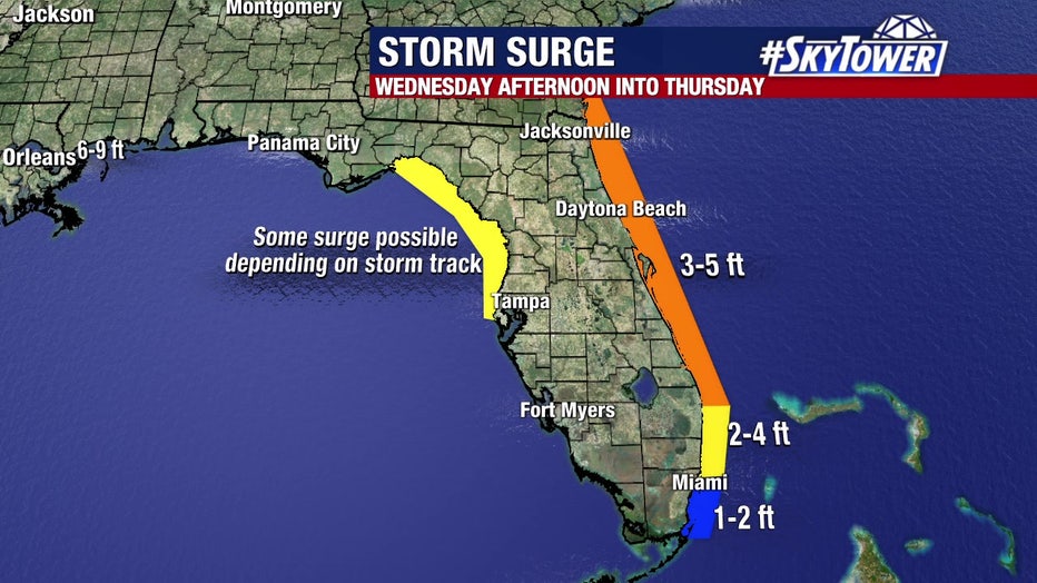
Based on the current forecast track, storm surge is possible Thursday from Pinellas County to the Big Bend if Nicole enters the Gulf.
READ: Tropical Storm Nicole closures, sandbags, storm information for Tampa Bay area
At a news conference in Tallahassee, Gov. Ron DeSantis said winds were the biggest concern and that significant power outages could occur, but that 16,000 linemen were on standby to restore power, as well as 600 guardsmen and seven search and rescue teams.
"It will affect huge parts of the state of Florida all day," DeSantis said.
The National Hurricane Center warns that hurricane conditions are expected across portions of Florida's east coast beginning Wednesday evening, and tropical storm conditions have already begun there.
Despite reaching hurricane status, FOX Chief Meteorologist Paul Dellegatto says the forecast will not likely change for the Bay Area. He says we will see more showers tonight. He says by tomorrow morning we will see several inches of rain with winds reaching 40-60 miles per hour.
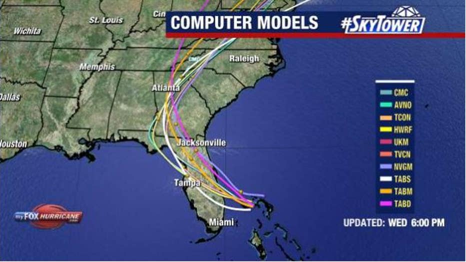
Dellegatto says Hurricane Nicole is moving west at 12 miles an hour. He says Hurricane Nicole should make landfall on Florida’s east coast around 1 a.m. on Thursday and will hit the Big Bend area around 1 p.m.
He says any deviation from this track or cone will not really change the weather all that much.
"Just about everybody across Central and North Florida will experience a period of tropical storm-force winds and rain squalls tonight through Thursday," Eliasen said. "Late Wednesday night through Thursday morning will be the window for the worst weather across Central Florida."
Meanwhile, NHC forecasters warn that a dangerous storm surge is expected along much of the state's east coast.
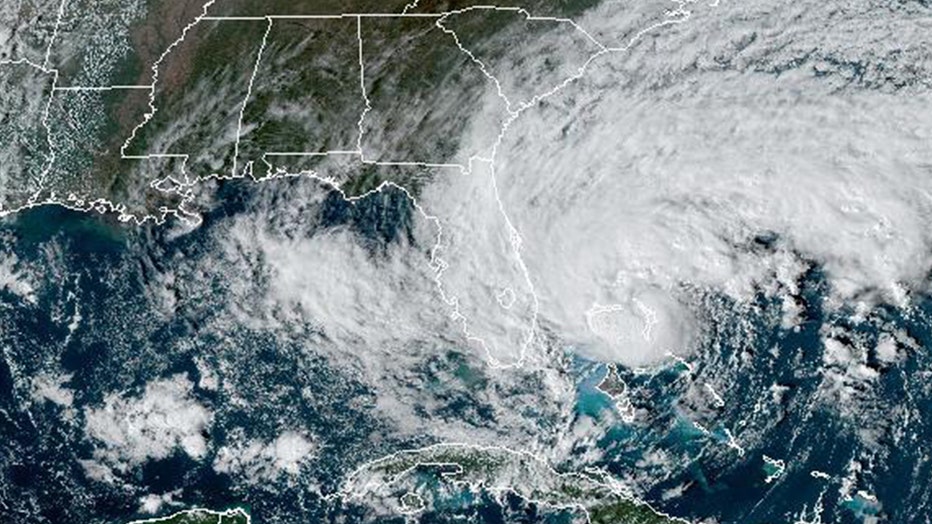
NOAA satellite image shows Tropical Storm Nicole after making landfall in the Bahamas on Nov. 9, 2022.
Residents in at least three Florida counties — Flagler, Palm Beach, and Volusia — were ordered to evacuate from barrier islands, low-lying areas and mobile homes. The evacuation orders took effect Wednesday. Officials at Orlando International Airport, the seventh busiest in the U.S., said commercial operations would stop Wednesday afternoon until it was safe to resume flights.
"This incoming storm is a direct threat to both property and life," said Volusia County Manager George Recktenwald. "Our infrastructure, particularly along the coastline, is very vulnerable because of Hurricane Ian."

LINK: Track Nicole on MyFOXHurricane.com
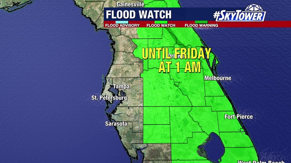
A range of warnings and watches remain in place. Many areas are still reeling from damage caused by Hurricane Ian, which hit Florida’s southwestern Gulf Coast as a Category 4 storm in late September before dumping heavy amounts of rain across much of the central part of the state. Forecasters said heavy rain could fall on areas still recovering from Ian's flooding.
Hurricane warnings were in effect for the Abacos, Berry Islands, Bimini, and Grand Bahama Island, the Miami-based National Hurricane Center said in an advisory. Other areas of the Bahamas, including Andros Island, New Province, and Eleuthera remained under a tropical storm warning.
The hurricane center said the storm's track shifted slightly south overnight, but the exact path remains uncertain as it approaches Florida, where it is expected to make landfall as a Category 1 hurricane late Wednesday or early Thursday. However, forecasters are warning residents to not focus on the exact track of Nicole since it is expected to be a large storm "with hazards extending well to the north of the center, outside the forecast cone."
RELATED: Preparations underway for Nicole as Tampa Bay area residents still recover from Hurricane Ian
Jack Beven, a National Hurricane Center forecaster, said the storm has a "very large cyclonic envelope," meaning that even if it makes landfall along the central Florida coastline, the effects will be felt as far north as Georgia.
By Tuesday night, hurricane warnings were issued for a large portion of Florida's Atlantic Coast, from Boca Raton to north of Daytona Beach.
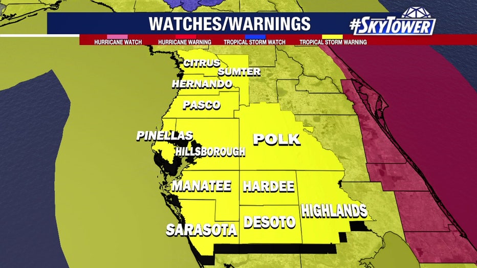
Tropical storm warnings are now in place for:
- Hallandale Beach Florida to Boca Raton Florida
- Flagler/Volusia County Line Florida to South Santee River South Carolina
- North of Bonita Beach to Indian Pass Florida
- Lake Okeechobee
Hurricane warnings are issued for:
- Boca Raton to Flagler/Volusia County Line Florida
Storm surge warnings are issued for:
- North Palm Beach Florida to Altamaha Sound Georgia
- Mouth of the St. Johns River to Georgetown Florida
- Anclote River Florida to Ochlockonee River Florida
RELATED: North Port residents still left with debris piles, tarped roofs ahead of Tropical Storm Nicole
NASA announced that because of the storm, next week’s planned launch of its much-anticipated moon rocket will be pushed back two days to Nov. 16. The 322-foot rocket will send an empty crew capsule around the moon and back in a dramatic flight test before astronauts climb aboard in a couple of years.
However, the storm did not have any impact on voting in Florida on Tuesday.
Preparations for Tropical Storm Nicole
Preparations are underway across the Tampa Bay area for Tropical Storm Nicole. Officials are encouraging all residents to keep all close eye on their city and county's social media feeds for the latest updates.
The mandatory evacuation order in Palm Beach County affects 52,000 residents of mobile homes and 67,000 residents of barrier islands, officials said in an afternoon news conference. Shelters up and down the coast were opening at 7 a.m. Wednesday, officials said.
Schools will be closed in multiple counties across Florida as the storm approaches. Some announced closures through Friday, already an off day because of the Veteran's Day holiday. Other districts have said they would cancel classes on Thursday. The University of Central Florida, one of the largest U.S. universities with 70,000 students and 12,000 employees, was closing on Wednesday and Thursday.
Walt Disney World outside Orlando will close Wednesday and will likely reopen Thursday.
Peace River flooding concerns residents
Hurricane Ian flooded homes near the Peace River. With Tropical Storm Nicole threatening to bring more flooding, residents aren't taking any chances.
When Ian hit a few weeks ago, Hurricane Ian flooded the Peace River, and the pump station at Peace River Village in Polk County broke, and sewers gushed into the flood water that covered nearby streets.
Although Nicole is not expected to be nearly as destructive, Peace River Village residents are keeping a close eye on the storm. So are emergency operations staffers.
On Tuesday, experts were predicting that the Peace River was going to rise, but not nearly as dramatically as it did with Ian.
RELATED: Polk County, residents near Peace River, brace for flooding ahead of Tropical Storm Nicole
Meanwhile, streets in North Port are still lined with debris piles waiting to be picked up as residents prepare for Tropical Storm Nicole. The city also said it's time to make sure tarps are secure with many also still waiting for roof repairs in the aftermath of Hurricane Ian.
The City of North Port has collected 1.2 million cubic yards of debris, but many piles remain.
Michael Fear, the city's emergency manager, said residents are asked to keep debris piles low if possible and make sure heavier material is on top. He said it's to prevent insulation, aluminum and other materials from flying around and also clogging drains and waterways.
Tropical Storm Nicole raises concerns in Sarasota County
With so much Hurricane Ian debris still around Sarasota County, Tropical Storm Nicole is the last thing any residents want to think about.
The city is expecting about 2-4 inches of rain from Nicole.
"We are pretty much prepared, going through all the motions that we all go through just in case because we know this is a possibility," Fear said.
After weathering Hurricane Ian, many remain exhausted and ready to move on.
RELATED: What is the difference between a tropical storm and a subtropical storm?
In South Carolina, forecasters warned several days of onshore winds from Nicole could pile seawater into places like downtown Charleston. Thursday morning’s high tide was predicted to be higher than the water level from Hurricane Ian.
Tropical storm-force winds extend outward up to 380 miles from the center of the storm, the National Hurricane Center's advisory said.
MORE: When was the last time a hurricane made landfall on Florida's east coast in November? 1935
The Atlantic hurricane season runs from June 1 through Nov. 30. The last storm to hit Florida in November was Tropical Storm Eta, which made landfall in Cedar Key, on the state’s Gulf Coast, on Nov. 12, 2020.
Since record-keeping began in 1853, Florida has had only two hurricanes make landfall in November, said Maria Torres, a spokesperson for the Hurricane Center. The first was the Yankee Hurricane in 1935, and the second was Hurricane Kate, which struck Florida's Panhandle as a Category 2 storm in 1985.
The Associated Press contributed to this report.

