

Tropical Storm Watch issued for Florida's Gulf Coast; Nicole strengthens into tropical storm
TAMPA, Fla. - Nicole has strengthened from a subtropical storm into a tropical storm, the National Hurricane Center says. Much of Florida's Gulf Coast, including the Tampa Bay area, is now under a Tropical Storm Watch as the system churns in the Atlantic, and is expected to make landfall as a Category 1 hurricane later this week.
The storm is beginning to move around an east ridge as it slowly intensifies, reports FOX 13's chief meteorologist Paul Dellegatto, adding that the wind field of Nicole is large. The worst of the winds will likely be Wednesday night and through the day Thursday for most of the Bay Area.
"So expect tropical storm conditions in most areas, especially inland/north. Coastal flooding from point of landfall north," he noted.
On Tuesday, hurricane warnings were issued for a large portion of Florida's Atlantic Coast, from Boca Raton to north of Daytona Beach. Tropical storm warnings are in place for other parts of the Florida coast, all the way to Altamaha Sound, Georgia. The warning area also stretches inland, covering Florida's Lake Okeechobee, with tropical storm watches in effect on the state's Gulf Coast — from Bonita Beach in southwest Florida to the Ochlockonee River in the Panhandle.

10 p.m. track for Tropical Storm Nicole on Nov. 8, 2022.
NHC forecasters said the storm has a "very large cyclonic envelope," meaning that even if it makes landfall along the central Florida coastline, the effects will be felt as far north as Georgia.
However, the storm was not expected to have any impact on voting in Florida on Tuesday.
Nicole is forecast to gradually strengthen before approaching Florida, and is expected to become a hurricane with winds over 74 miles per hour by Wednesday while it is moving near or over the Bahamas.
The storm is moving northwest, though the NHC says its track has shifted northward slightly since its last advisory.
Forecasters say Nicole is expected to begin strengthening later today, helped by warmer waters closer to the Bahamas and Florida's east coast.
LINK: Track Nicole on MyFOXHurricane.com
What is the difference between a tropical storm and a subtropical storm?
A tropical storm is a tropical cyclone with maximum sustained winds between 39 and 73 mph.
A subtropical storm is sort of a hybrid storm, meaning it has characteristics of both a typical low-pressure system and a tropical cyclone. However, unlike the typical low, a subtropical storm gets a lot of its energy from warm ocean water and has maximum sustained winds of at least 39 mph, according to FOX Weather.
If either of these types of systems generates winds of at least 74 mph, they become hurricanes.
A system becomes a post-tropical cyclone once it loses its tropical characteristics. However, these types of storms can still pose a danger with heavy rain and high winds.
RELATED: Elevated red tide levels detected at Sarasota County beaches after Hurricane Ian
What impacts will we see in the Tampa Bay area?
"This doesn’t look purely tropical in nature. The heaviest area of wins is displaced a couple of hundred miles to the east of where the center is," explained FOX 13's meteorologist Dave Osterberg. "One on hand, a subtropical system is not rapidly going to intensify because it’s such a broad system and it’s large, it will take some time for that to happen. On the flip side, because it’s such a large storm, as it approaches the east coast of our state, you’re going to feel the impacts from the Keys, all the way to the Carolinas."
For the Bay Area, this means rain and wind, based on Nicole's current projected path.
"In a path like that, we will obviously get some rain and wind from this because tropical storm-force winds go out like 300 miles from the center of the storm," Osterberg explained.
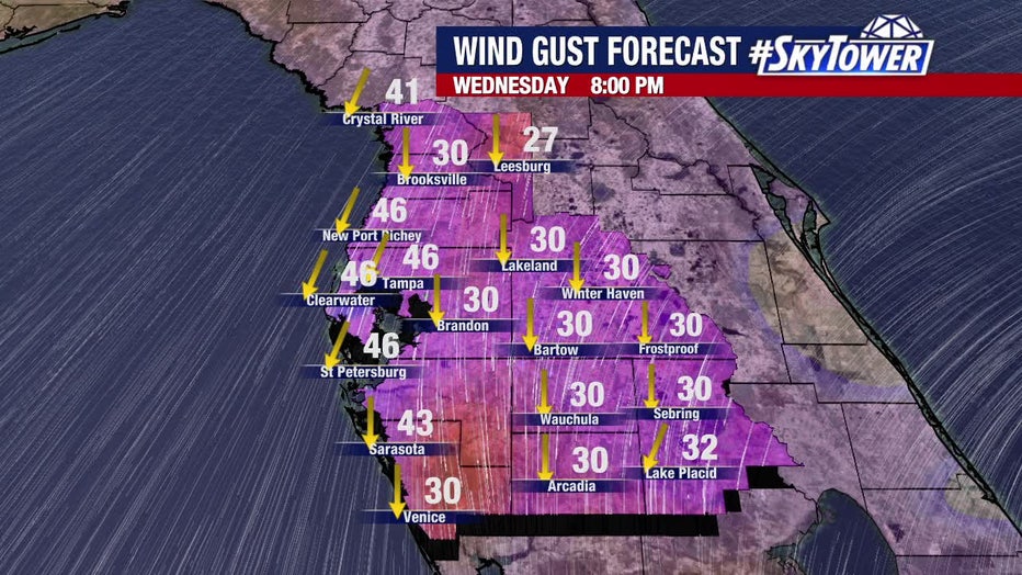
He said depending on the storm's track, we can expect 30 to 45 mph wind gusts and 2 to 4 inches of rain in the region, but stresses that Nicole will mainly be a rain event for the Tampa Bay area.
"The second this is to touch [the east coast], it's going to start to weaken significantly," he said. "This is a very, just wet, wet setup is what we're looking at for Thursday, especially Thursday morning."
FOX 13 meteorologist Tyler Eliasen added, "For those on the west coast of Florida – especially in areas hard hit by Hurricane Ian – rest assured that storms with this angle of approach usually are more of a nuisance than anything else in terms of impacts around. That being said, some tropical storm-force wind gusts and periods of rain wouldn’t exactly be ideal for folks still trying to recover."
Local preparations
Pasco County is declaring a local state of emergency and opening two self-serve sandbag sites for residents (you must bring your own shovel):
- Magnolia Valley Golf Course: 7223 Massachusetts Avenue, New Port Richey
- Pasco County Public Works (C-Barn): 30908 Warder Road, San Antonio
Dade City is also opening its own sandbag site at the former Dade City Police Department Building, located at 38042 Pasco Avenue.
Pasco County Public Schools announced that all campuses and offices will be closed on Thursday, Nov. 10, "due to concerns regarding the expected dangerously high winds" from the storm. All before and after-school programs will be closed on Thursday as well.
In Sarasota County, the city of North Port is opening its own self-serve sandbag station behind the George Mullen Activity Center, located at 1602 Kramer Way.
State of emergency issued
By Monday afternoon, Gov. Ron DeSantis issued a state of emergency was issued for 34 Florida counties: Brevard, Broward, Charlotte, Citrus, Clay, Collier, DeSoto, Duval, Flagler, Glades, Hardee, Hendry, Highlands, Hillsborough, Indian River, Lake, Lee, Manatee, Martin, Miami-Dade, Nassau, Okeechobee, Orange, Osceola, Palm Beach, Pasco, Polk, Putnam, Sarasota, Seminole, St. Johns, St. Lucie, Sumter, and Volusia.
Basically, it means state and local governments have more freedom to coordinate emergency agencies and resources to deal with a storm threat, rather than going through normal procedures.
"While this storm does not, at this time, appear that it will become much stronger, I urge all Floridians to be prepared and to listen to announcements from local emergency management officials," according to a written statement from DeSantis. "We will continue to monitor the trajectory and strength of this storm as it moves towards Florida."
The Atlantic hurricane season runs from June 1 through Nov. 30. The last storm to hit Florida in November was Tropical Storm Eta, which made landfall in Cedar Key, on the state’s Gulf Coast, on Nov. 12, 2020.
Since record keeping began in 1853, Florida has had only two hurricanes make landfall in November, said Maria Torres, a spokesperson for the Hurricane Center. The first was the Yankee Hurricane in 1935, and the second was Hurricane Kate, which struck Florida's Panhandle as a Category 2 storm in 1985.