


Nash Rhodes
Nash Rhodes joins the FOX13 weather team from Fort Myers, Florida.
He was born and raised in Nashville, Tennessee, and earned his meteorology degree from The University of Oklahoma, with additional degrees in broadcast, business, and a certification in Intelligence Studies.
Nash has years of experience covering tornadoes and hurricanes across Florida's Gulf Coast. This notably includes Category 5 Hurricane Ian which directly impacted and flooded his former station during their coverage.
His early interest in storms was sparked by the frequent severe weather gatherings his family hosted, thanks to having one of the few storm shelters in the neighborhood. This sparked Nash's fascination with severe weather coverage and learning to analyze Doppler radar.
Beyond work, you can find him outdoors enjoying nature. Nash is fond of kayaking, playing tennis, and hiking the scenic trails across Florida. He is also an avid football fan and will always be rooting for his Tennessee Titans and Oklahoma Sooners whenever they play.
The latest from Nash Rhodes

Tropical Depression Two forms: What it means for your week
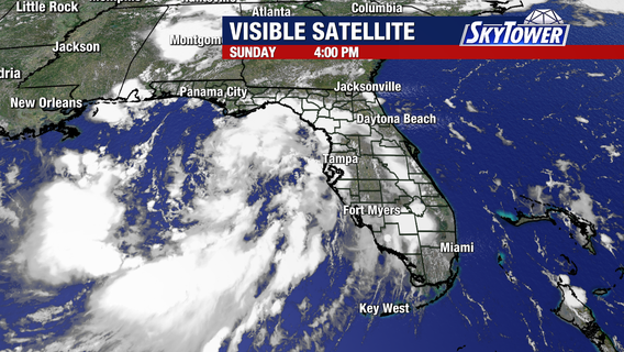
Tropical Depression Two formed off Florida’s west coast Sunday morning and is expected to become Tropical Storm Bertha within the next day or two as it continues to organize.


Tropical Depression Two forms in Gulf, Tropical Storm Watch issued for portions of Florida Panhandle
Forecasters are monitoring Tropical Depression Two in the Eastern Gulf, which now has a higher chance of developing over the next few days.
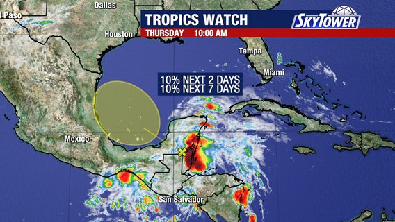

National Hurricane Center tracks tropical wave entering Bay of Campeche
A tropical wave tracking across the Yucatan Peninsula will push into the Bay of Campeche over the next couple of days, bringing a small chance of tropical development. The National Hurricane Center is monitoring the system, which is expected to stay far away from Florida.
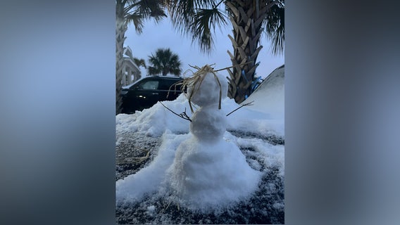

Will it snow in Tampa? Rare 'Gulf-effect' setup could bring flakes this weekend
There’s been some online buzz about the very small chance of snow in parts of the Bay Area.


2025 Atlantic hurricane season comes to an end
The 2025 Atlantic hurricane season has officially wrapped up, and this year Florida caught a break.


Hurricane Melissa to brush Bermuda as Category 2 storm after blasting Jamaica and Cuba
Hurricane Melissa is now a Category 2 hurricane that will soon pass by the tiny island of Bermuda.


Tracking Invest 98L as it approaches the Caribbean
Invest 98L now has a 70% (medium) chance of developing into a named storm in the Caribbean within the next seven days.


Tracking Jerry and a new tropical wave
Jerry continues to struggle against moderate wind shear in the west-central Atlantic.


High chance of tropical development this week
The signal for a tropical depression or tropical storm to develop in the central tropical Atlantic continues to climb. There is now a high (70%) chance of formation assigned to Invest 95L, with a 50% chance that formation could occur early next week.


Tropical development expected next week
A tropical depression is possible by the middle of next week as the odds of development are at 60% and 10% in the next 48 hours.