Florida to see 'dirty rain' as plume of Saharan dust layer arrives this weekend
Tropics remain quiet with Saharan dust approaching
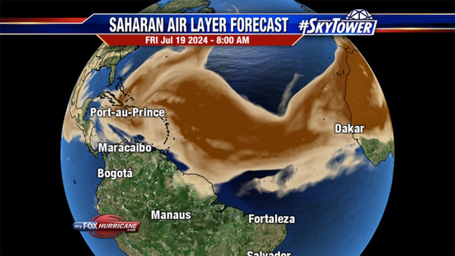
FOX 13 Meteorologist Jim Weber took a look at the big plume of Saharan air moving over the Atlantic with another cloud behind it, keeping the tropics quiet.
TAMPA, Fla. - Usually, a good downpour can help wash the ground clean, but storms in Florida this weekend may leave things dirtier than before the rains began.
A thick layer of Saharan dust that is among the massive plume covering much of the tropical Atlantic is forecast to move across the Florida Peninsula.
READ: Saharan dust helps keep tropical Atlantic quiet
The dust usually moves through between 5,000 and 15,000 feet, but summer thunderstorms can stretch 20,000-40,000 feet tall in Florida. While the dust can work to dry out the atmosphere, sapping storms from some rainfall, the abundance of tropical moisture can still win the day, bringing occasional downpours.

Rainfall amounts are expected to reach 1-2 inches across the central Florida Peninsula with 2-3 inches possible in southwestern Florida.
With the Saharan layer mixed in, the raindrops will now carry dust particles with them creating a so-called "dirty rain", leaving a film on cars, windows and homes.
"You have this creepy layer of gross stuff on your car; you’re like, it’s not pollen, it’s dust," FOX Weather Meteorologist Britta Merwin said. "Look out for the dust collecting. Also, if it lands on your (air conditioner) it can clog it up, so (it's a) good idea to spray off your units."
The Saharan dust plume originates more than 3,000 miles away from northern Africa. Hot, dry air rises from the Saharan Desert, carrying fine particles of dust from the sands. That dust-laden air climbs to the highest reaches of the atmosphere, where winds called the Easterlies or Trade Winds (blowing from east to west) carry that dust across the Atlantic Ocean into the Western Hemisphere.
The dry layer will inhibit tropical storm development and can give a milky haze to the air that makes for colorful sunrises and sunsets. A vast majority of the dust stays aloft, but as some dust makes it to the surface it can degrade air quality.

