

Hurricane Beryl remains a Category 4 storm, 'life-threatening' conditions likely Wednesday in Jamaica

Beryl now a strong Category 4 approaching Jamaica
FOX 13 meteorologist Jim Weber has the latest track for Hurricane Beryl, which is expected to impact Jamaica late Wednesday before heading toward the Yucatan Peninsula and Belize.
TAMPA, Fla. - Hurricane Beryl has weakened slightly, but remains a powerful Category 4 storm as it heads toward Jamaica.
Peak winds have dropped from 165 mph -- strong enough for Category 5 status -- earlier Tuesday to 150 mph. Along with the drop in winds, the pressure has risen, which is another sign the storm is weakening. A lower barometric pressure means a stronger or strengthening storm.
This is still a major hurricane as it approaches Jamaica and the Cayman Islands. The Cayman Islands are now included in the Hurricane Warning.
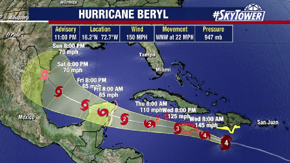
The brunt of this storm will impact these islands on Wednesday. Jamaica could take a direct hit from the eye, and if it doesn’t, the island will still get the worst part of the storm as it passes just to the south.
Hurricane-force winds extend 40 miles from the center, while tropical-storm-force winds extend out about 175 miles.
NHC predicts life-threatening storm surge of 5-8 feet above normal tide levels, along with 6 to 12 inches of rainfall.
The 11 p.m. advisory Tuesday keeps Beryl on a similar track to what we’ve been thinking. By Thursday-Friday, the storm will pass the Yucatan Peninsula and Belize, where further weakening is expected.
Beryl has now become the:
- Earliest Category 4 hurricane on record in the Atlantic
- Earliest Category 5 hurricane on record in the Atlantic
- Fastest identification of a hurricane before September in the Atlantic