

Hurricane Helene expected to reach Cat. 4 strength ahead of Florida landfall
Helene to bring 'catastrophic' winds, storm surge
Hurricane Helene is expected to start rapidly intensifying as it makes its approach to Florida. The storm is forecast to bring "catastrophic" winds and storm surge to the northeastern Gulf coast, according to the National Hurricane Center.
TAMPA, Fla. - Hurricane Helene is expected to start rapidly intensifying as it makes its approach to Florida. The storm is forecast to bring "catastrophic" winds and storm surge to the northeastern Gulf coast, according to the National Hurricane Center.
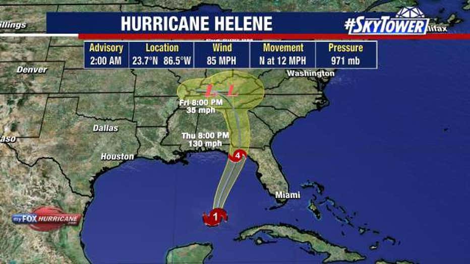
FOX 13 Meteorologists say Helene is forecast to reach Category 4 strength before it makes landfall in Florida’s Big Bend area on Thursday. It continues to move across warm Gulf waters as a Category 1 hurricane after reaching hurricane strength Wednesday morning.
As of 2 a.m. on Thursday, Helene was located at 23.7 N and 86.5 W, had maximum sustained winds of 85 miles an hour and was moving north at 12 miles an hour.
The National Hurricane Center said the storm will grow wider, leading to far-reaching impacts across the Bay Area and all of Central Florida, despite being outside the NHC's forecast cone.
FOX 13 Meteorologist Dave Osterberg said record high water temperatures will provide "unlimited fuel" for rapid intensification, which will help it strengthen as it moves up Florida's coast.
Storm watches and warnings
A hurricane warning is in effect from Anclote River to Mexico Beach. That includes coastal areas of Citrus, Hernando and Pasco counties.
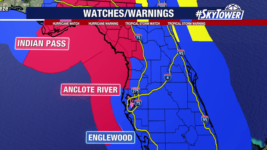
A tropical storm warning has been issued for the rest of the state except the western Panhandle.
A storm surge warning has been issued from Flamingo to Indian Pass, including Tampa Bay and Charlotte Harbor.
A flood watch is in effect until Friday morning across the Bay Area and much of the state.
READ: Your guide to hurricane season 2024
What is the timeline for impacts in the Bay Area?
Rainy and windy conditions are expected to arrive in the region early Thursday, with the strongest impacts being felt Thursday afternoon, according to Osterberg.
Osterberg said any shift in the track, even just a few miles, will significantly change how Helene will impact the Bay Area.
"There's not a lot of room for error. There really isn't for a storm like this and the large size that it is," Osterberg said.
How strong are the potential impacts from Helene?
FOX 13 meteorologists say life-threatening storm surge is expected to be a major issue, with the potential to reach 15 feet along the coast from Citrus County northward into the Big Bend.

Storm surge levels will vary depending on where you live. See the graphics below to see forecast storm surge for each area of Tampa Bay:
Wind gusts could top 70 miles an hour along the coast on Thursday afternoon, with tropical storm force winds extending as far as 250 miles from the center of the storm.

Significant rainfall is also expected, ranging from 5 to 10 inches on the coast to 2 to 4 inches inland.
Preparations for Helene
Hurricane Helene: County-by-county guide
Evacuation orders have been issued in several Bay Area counties, mainly for coastal and low-lying areas.
School closures have been announced in many districts, with some starting Wednesday and others beginning Thursday.
Some government offices will be closed in the coming days.
Gov. Ron DeSantis has declared a state of emergency for almost all Florida counties, while a few Bay Area counties have declared local states of emergency.
Power companies are staged in the Tampa Bay area, along with other parts of the state, to respond to power outages.
STAY CONNECTED WITH FOX 13 TAMPA BAY:
- Download the FOX Local app for your smart TV
- Download the FOX 13 News app for breaking news alerts, latest headlines
- Download the SkyTower Radar app
- Sign up for FOX 13’s daily newsletter