

Hurricane Milton tracker: Storm remains Cat. 5 as it approaches Florida’s Gulf coast
Hurricane Milton: Cat. 5 storm approaches Florida
Chief Meteorologist Paul Dellegatto and Meteorologist Nash Rhodes track the latest on Hurricane Milton.
TAMPA, Fla. - Hurricane Milton remains a Category 5 storm Monday evening as the storm approaches Florida's Gulf coast.
As of 11 p.m. on Monday, the major hurricane was located at 21.8N and 89.9W. The National Hurricane Center said it had maximum sustained winds of 165 miles per hour and was moving east at nine miles an hour in the Gulf of Mexico.
Hurricane Milton: County-by-county guide
According to the NHC, the central pressure in the eye of Milton has fallen to a near record low as the storm sets its sights on Florida’s west coast.

Radar data shows Milton could be at the beginning of an eyewall replacement cycle, with some signs of a moat and a partial outer eyewall. This will likely cause the system to gradually weaken on Tuesday but grow larger.
On Wednesday, Milton is expected to encounter a less favorable environment with strong shear and dry air entertainment, which meteorologists believe will weaken the storm.
Regardless, Hurricane Milton is expected to be a large, powerful hurricane when it makes landfall on Florida’s west coast.
READ: What is a Category 5 hurricane?
Milton is forecast to remain a hurricane as it crosses the Florida Peninsula and life-threatening hurricane-force winds, especially in gusts, are expected to spread inland across a portion of the entire state.
According to the National Hurricane Center, Milton could be one of the most destructive hurricanes on record for west-central Florida.
Watches and warnings
A Hurricane Warning is in effect for Florida's west coast from Bonita Beach northward to the mouth of the Suwannee River, including Tampa Bay.
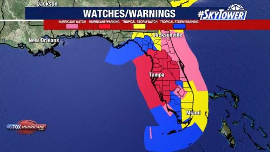
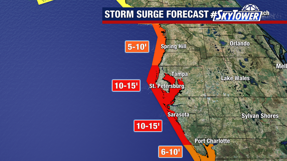
A Storm Surge Warning has been issued for the west coast of Florida from Flamingo northward to the Suwannee River, including Charlotte Harbor and Tampa Bay.
A Flood Watch is in effect for the entire Tampa Bay area, most of Central Florida and all of South Florida.
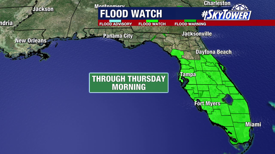
The entire Tampa Bay area is under a flood watch through Thursday morning, along with much of Central Florida and all of South Florida.
What is the difference between a watch and a warning?
A Hurricane Warning means that hurricane conditions are expected somewhere within the warning area. A warning is typically issued 36 hours before the anticipated first occurrence of tropical-storm-force winds, conditions that make outside preparations difficult or dangerous.
A Hurricane Watch means that hurricane conditions are possible within the watch area. A watch is typically issued 48 hours before the anticipated first occurrence of tropical-storm-force winds, conditions that make outside preparations difficult or dangerous.
Hurricane Milton: Mandatory evacuations begin in Tampa Bay Area
A Storm Surge Warning means there is a danger of life-threatening inundation, from rising water moving inland from the coastline, during the next 36 hours in the indicated locations.
A Storm Surge Watch means there is a possibility of life-threatening inundation, from rising water moving inland from the coastline, in the indicated locations during the next 48 hours.
When will impacts be felt in the Bay Area?
Some areas will receive heavy rainfall on Monday and Tuesday, which FOX 13 meteorologists say is not directly related to Milton.
Rain from Milton will likely arrive on Wednesday and will continue into Thursday before the storm moves out.
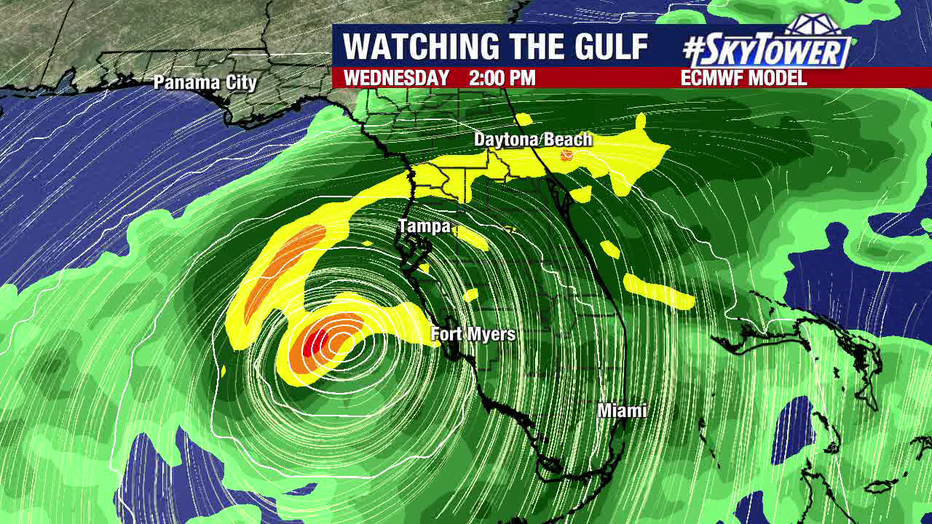
Hurricane Milton is expected to significantly impact the Tampa Bay area, with several inches of widespread rain likely.
Depending on the exact path Milton takes, the heaviest rainfall is expected to be from the I-4 corridor and southward, with several inches – even up to a foot in some areas – likely over the next week.
Hurricane Milton: Bay Area schools close due to storm
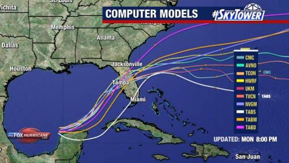
As for other significant impacts, like wind and life-threatening storm surge, FOX 13 Meteorologist Dave Osterberg says the point of landfall will be critical in determining where the worst of Milton is felt.
"While we have some answers today, we don't have others," Osterberg said. "What I can't answer is where exactly it's going to make landfall and how much it's going to weaken before it makes landfall."
FOX 13 Chief Meteorologist Paul Dellegatto warns that even if Milton does weaken prior to landfall, it will not lessen the storm surge. The point of landfall south is where the biggest surge will occur, with the latest forecast calling for 8 to 12 feet from Anclote south to the Fort Myers Beach area.
STAY CONNECTED WITH FOX 13 TAMPA BAY:
- Download the FOX Local app for your smart TV
- Download the FOX 13 News app for breaking news alerts, latest headlines
- Download the SkyTower Radar app
- Sign up for FOX 13’s daily newsletter