

Invest 94L moving through the Atlantic, no immediate threat to Florida

Invest 94L could develop in Atlantic
The area is not a threat to Florida at this time. According to FOX 13 News Meteorologist Valerie Mills, if Invest 94L becomes a tropical storm it will be called Nadine.
TAMPA, Fla. - A tropical disturbance dubbed Invest 94L is moving through the Atlantic Ocean and could develop several days from now, but FOX 13 meteorologists say there's a good chance it won't impact Florida.
The National Hurricane Center is giving the area a 10 percent chance of development in the next two days, then a 50 percent chance in the next seven days as it enters an area that's more conducive for development.
Models show Invest 94L approaching the Leeward Islands and the Caribbean later this week, but some of the models show the disturbance curving to the north before it can reach the mainland U.S. Others take it west, at which point it would likely head toward Central America.

Models show Invest 94L approaching the Leeward Islands and the Caribbean, with many models taking the system north before reaching the U.S.
What could protect Florida?
FOX 13 Meteorologist Valerie Mills says a dip in the jet stream with cold fronts moving into Florida could block the state from taking another direct hit, even if Invest 94L does develop into something more.
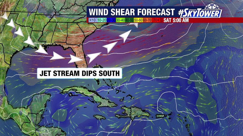
FOX 13 meteorologists say a dip in the jet stream could protect Florida from taking a direct hit from a storm, if one develops, in the coming days.
"Think about it as: these winds will steer it up north," Mills said. "So this is actually going to help us out in the week ahead."
The next storm that develops will get the name Nadine, with FOX 13 meteorologists emphasizing that has not happened yet, despite persistent rumors on social media.
The NHC is not currently tracking any other areas of interest in the Atlantic Basin.
STAY CONNECTED WITH FOX 13 TAMPA BAY:
- Download the FOX Local app for your smart TV
- Download the FOX 13 News app for breaking news alerts, latest headlines
- Download the SkyTower Radar app
- Sign up for FOX 13’s daily newsletter