

NHC monitoring 2 tropical disturbances, Florida impacts 'unlikely'
Cold front to keep Invest 94L south of Florida
FOX 13 Meteorologist Jim Weber is keeping an eye on several systems in the tropics but stresses that nothing is headed toward the Bay Area. Weber says something is slowing trying to develop in the Southwestern Caribbean and will work its way into Central America. He adds that there is nothing that will bring the system up into the Gulf of Mexico. He is also watching Invest 94L in the Atlantic that is moving west across an environment that is favorable for development. According to Weber a cold front that will cross the Bay Area this week will keep invest 94L south of Florida.
TAMPA, Fla. - The National Hurricane Center is watching two disturbances in the tropics, which FOX 13 meteorologists say will likely not directly impact Florida.
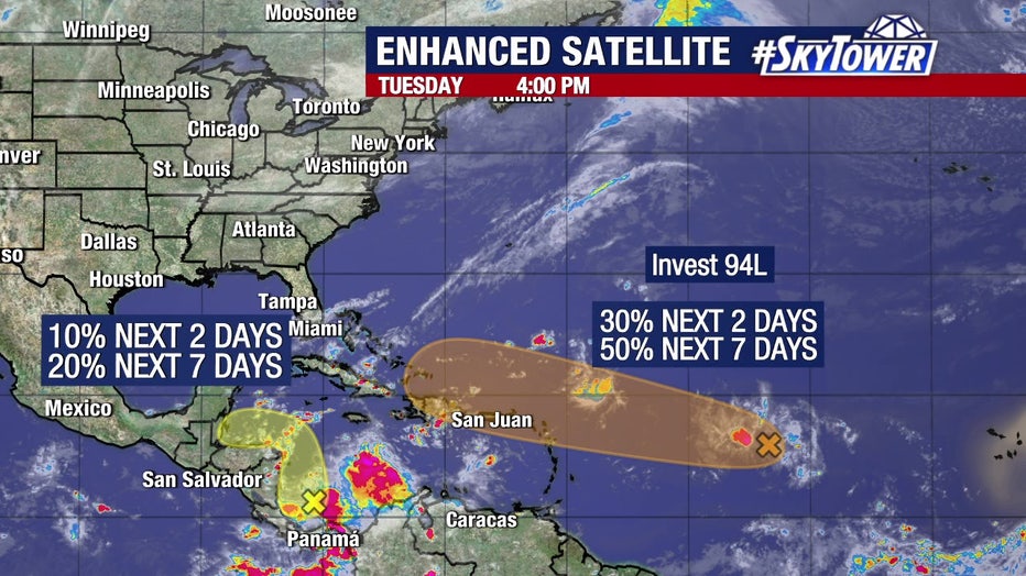
Invest 94L in the Atlantic
Invest 94L is moving west over the Atlantic Ocean. As of Tuesday morning, the NHC is giving it a 50 percent chance of development over the next seven days as it approaches the Leeward Islands and the Caribbean.

Even if the area does develop into a significant storm, models show it turning to the south or the north, avoiding Florida.
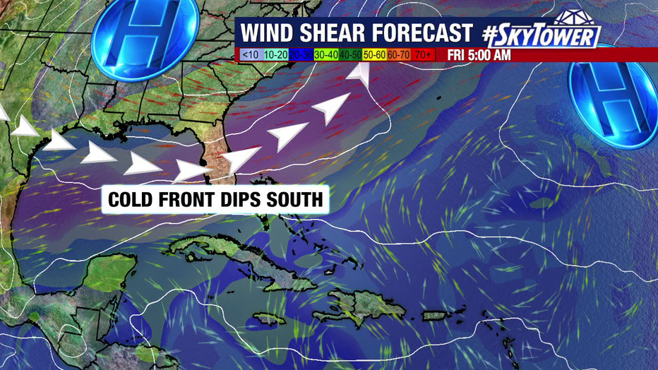
FOX 13 meteorologists say a cold front will bring dry air and a strong steering current, turning any potential storms away from Florida.
The reason Florida is "unlikely" to get hit, according to FOX 13 meteorologist Valerie Mills, is our first fall cold front moving in this week. That will bring drier air and wind shear over the state, with a strong steering flow acting as a "block."
"So at this point, it's not an area of concern for us," Mills said.
Another wave near Central America
The NHC is also highlighting an area near Central America, giving it a 20 percent chance to develop over the next seven days.
According to Mills, the disturbance will likely move west if it develops, avoiding the U.S.
The next system to develop will get the name Nadine.
STAY CONNECTED WITH FOX 13 TAMPA BAY:
- Download the FOX Local app for your smart TV
- Download the FOX 13 News app for breaking news alerts, latest headlines
- Download the SkyTower Radar app
- Sign up for FOX 13’s daily newsletter