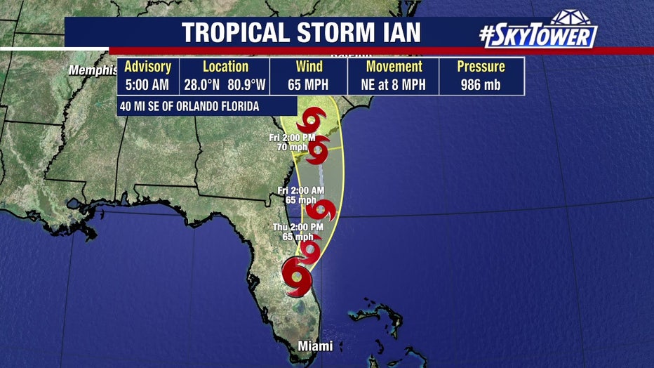
NHC warns of record river flooding in Tampa Bay area as residents begin cleanup from Hurricane Ian damage
Peace River flooding reaches record-high
The Peace River, which runs through Polk and Hardee counties, reached a record high of 25.26 feet before sunrise. That number is expected to rise.
While residents in parts of the Tampa Bay area feel spared by the worst of Hurricane Ian, many will be without power and cleaning up debris for days due to strong winds during the storm. However, the National Hurricane Center warned that central Florida still faces a significant threat of flooding due to the devastating storm.
In the NHC's 5 a.m. advisory downgrading Ian to a tropical storm, forecasters said that, though Ian may have moved past the Tampa Bay area, its troubles were not over when it comes to water dangers.
"Widespread, life-threatening catastrophic flooding, with major to record river flooding, will continue today across portions of central Florida," the NHC said.
Record flooding possible
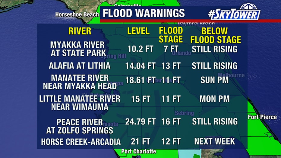
Flood warnings are in effect for multiple rivers, many of which are already several feet above their flood stage — and still rising.
"As far as heavy accumulating flooding rain, we are done, but it did its damage because now with 10 and 15 inches of rain that came in and around the area east and south of Tampa, the rivers are filling up — and they are filling up quickly," FOX 13 Meteorologist Dave Osterberg said.
Some rivers could reach record levels in the coming days, especially in Sarasota, Manatee and Hardee counties.
In particular, the Peace River at Zolfo Springs, which has a flood stage of 16 feet, already reached a record high of 25.36 feet as of 6 a.m. Thursday — but it was expected to jump to at least 26 feet before gradually receding.
Polk County: Peace River remains a concern, flooding reported in nearby mobile home park
Officials in Polk County said, as of 6 a.m., half of the county is without power and it is still unsafe to assess the damage before daylight. Their biggest concern is the Peace River Village MHP and areas surrounding the river.
Polk County's Director of Emergency Management Paul Womble said they are getting reports of flooding at the Peace River Village Mobile Home Park, describing the community as "one of our biggest areas of concern."
Womble said the southern portion of the county got a lot of rain, which will all drain into the Peace River as well in about a day's time.
"It’s going to take some time, folks," Osterberg said. "Please avoid anything to do or near our major rivers for a while because the water is going to drain into those and eventually it will drain out. It could take days in some cases… or a couple of weeks."
Hillsborough County emergency officials also warned residents along the floodplains of Little Manatee and Alafia rivers to watch rising water levels outside their homes. If the water does approach homes, officials said residents should evacuate immediately.
The Little Manatee River is expected to rise Thursday evening and the Alafia is expected to rise Friday evening.
Track changes caught some off guard
Hurricane Ian made landfall around 2:30 p.m. Wednesday, near Sanibel Island and Captiva Island in Southwest Florida, as a strong Category 4 storm.
The area was somewhat caught off guard after the storm's projected path began to shift south a day before. Residents had little time to evacuate their homes before feet of water rushed in.
For days, the National Hurricane Center emphasized a high level of uncertainty for Ian's projected path toward Florida's west coast. Still, many areas hardest-hit by the storm were not included in some forecast cones in the week before the storm.
After the storm's path became clear, residents from Lee to Pinellas counties watched live radar views closely while bracing for the storm's impacts.
In Placida, Florida, a multi-level structure at Gasparilla Marina collapsed, destroying dozens of boats.
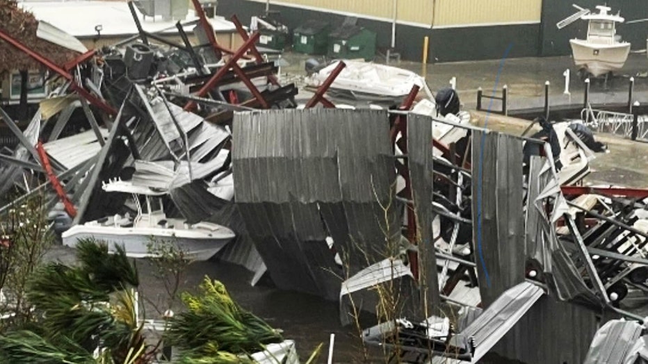
Gasparilla Marina damaged during Hurricane Ian
Now, the storm is on its way out as a tropical storm without a well-defined eye – and the focus is on cleaning up the damage.
Sarasota International Airport sustains roof, water damage due to Hurricane Ian
Hurricane Ian's winds ripped off a flexible membrane of the Sarasota airport's roof, causing water damage inside the building. Airport officials say cleanup is already underway and they are hoping to reopen by Saturday at the latest.
READ: Sarasota Bradenton International Airport aims to reopen by weekend after roof, water damage
Over at the SRQ airport, they are hoping to reopen by late Friday or Saturday morning after part of the terminal roof ripped off during Ian.
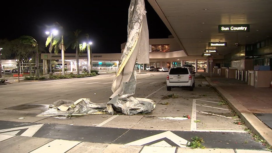
Rick Piccolo, the president and executive officer of the Sarasota Bradenton International Airport, said this is just a "small part" of the roof membrane that ripped off during Ian. The rest is still on the roof. (FOX 13 / File)
Inside Park East Club Mobile Home Park, the wind caused the main damage throughout. It’s a 55 and older community on South Tamiami Trail in Sarasota.
Ceilings caved in, and curled metal roofs were sitting in roadways and backyards. A carport was peeled back like a piece of foil.
Watch storm chasers try to stand in 150mph winds in Southwest Florida
Video from Joel Franco shows storm chasers and weather reporters on the street in Punta Gorda as the storm blew through. At one point, a quick-moving tree branch trips up meteorologist Jim Cantore. Courtesy Storyful
MORE: Tree branch hits Jim Cantore during Hurricane Ian report: 'Just give me a minute'
In Tampa Bay area counties, power outages, flooded roads and downed trees posed hazards for more than a million residents Wednesday night.
In Pinellas County, Duke Electric Company was already working overtime to remove any live power lines that had been broken by trees or other debris.
Wind takes down trees, power across Hillsborough County from Hurricane Ian
FOX 13's Haley Hinds shows the damage left by Hurricane Ian across Hillsborough County, including Tampa.
Hurricane Ian leaves hazards for residents
Duke said Around 10,000 crews were mobilized from other states to help restore power. They'll start with any major lines and transformers that knock out power to large areas. Duke said it installed so-called self-healing technology on half of their lines, which they hope will prevent millions of customers from having to go without electricity.
People run for cover when transformers explode
Folks ran for cover when electric transformers sent sparks flying as Hurricane Ian moved across Florida. Courtesy: Robert Gardner
In Manatee County, gusty and sustained winds damaged boats docked in coastal areas.
Trees came down, streetlights went dark, and signs leaned after the winds pushed through. Officials urged residents to stay home if possible while crews worked to clean up debris and restore electricity.
Manatee County residents brace for long night as Ian moves past
Hurricane Ian battered Florida's southwest coast Wednesday. Residents in Manatee County were somewhat relieved to be spared of the storm's worst impacts, but they will still spend at least one night in the dark with widespread power outages.
Streetlights came off their lines in Ybor City, prompting Tampa police and Hillsborough County officials to urge residents to stay in their homes.
The Tampa Police Department posted dashcam video as the streetlight crashed to the ground.
Streetlight comes down in Ybor City during Hurricane Irma
The Tampa Police Department posted video of a streetlight coming down due to wind from Hurricane Ian, warning people to stay home unless travel is absolutely necessary.
Across Hillsborough County, huge trees took out fences and power lines. The sound of chainsaws is expected the day after a major storm by Florida natives and longtime residents.
One home in Thonotosassa had a tree crash through and crush their car, as well.
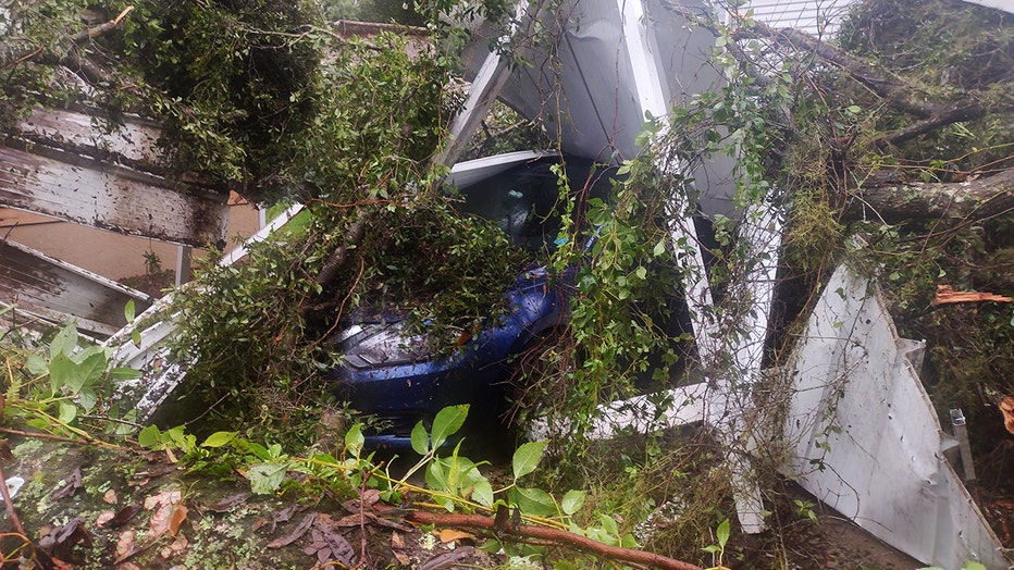
Tree topples onto home in Thonotosassa, crushing a resident's car
It might be the case for days as huge trees litter yards and streets across the area.
Residents asked to shelter in place as Hurricane Ian passes
FOX 13's Aaron Mesmer shows more reasons residents are being asked to stay home as Hurricane Ian continues to down trees, knock out power, and create flooding and impassible roads.
Widespread power outages
Power outages will also be the case around inland counties for at least a few days.
In all, over 2 million people are left in the dark across Florida due to Hurricane Ian.
You can monitor outages on each power company's website:
- Duke Energy - https://outagemap.duke-energy.com/#/current-outages/fl
- Florida Power & Light - https://www.fplmaps.com/
- Peace River Electric - https://www.preco.coop/services/outage-center/
- TECO - https://account.tecoenergy.com/outage/outagemap
- Lakeland Electric - https://lakelandelectric.com/storms-and-outages
- Withlacoochee River Electric - https://staticmap.wrec.net/
More than 1 million without power across Tampa Bay area
Hurricane Ian knocked out power for more than a million customers in the Bay Area.
Worst to come for Central Florida
Polk County was in the middle of the storm early Thursday. Rainfall totals were nearing 20-inches in some parts of Central Florida.
Hurricane Ian was forecast to move northeast across the state overnight into Thursday morning.
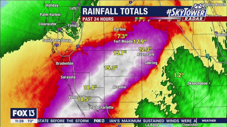
Rainfall totals as of 11:30 Wednesday night
The ECMWF rain forecast showed lower predicted totals earlier in the evening, putting Polk and Highlands County residents on edge for what was to come.
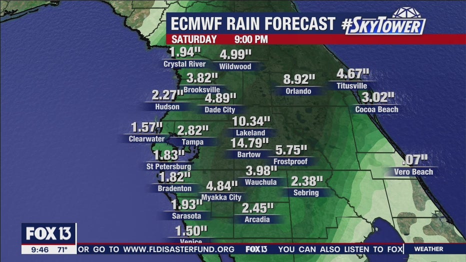
European Model projected rainfall totals Saturday at 10 p.m.
Sustained winds had slowed significantly early Thursday morning but gusts up to 60 miles per hour were still being reported at 1 a.m. The continued wind and rain would leave flooding and power outages behind for hundreds of thousands more residents.
The National Hurricane Center downgraded Ian to a tropical storm in its 5 a.m. advisory, and said the storm is expected to move out over the Atlantic Ocean later Thursday.
The storm was projected to again make landfall Friday, this time on the East Coast over South Carolina.
