

Invest 94L could become short-lived tropical depression near Cabo Verde
Newly developed wave in eastern Atlantic
FOX 13 News Meteorologist Valerie Mills says a strong dip in the jet stream keeps hurricanes away from Florida. Tropical Storm Leslie is moving away from the continental U.S. and a newly developed wave in the eastern Atlantic has a medium chance of formation, according to Mills.
TAMPA, Fla. - The National Hurricane Center says a tropical disturbance in the eastern Atlantic Ocean has a chance to develop into a short-lived tropical depression on Saturday, just three days after Hurricane Milton tore through Florida.
Invest 94L is currently not expected to impact Florida and there are no areas being tracked in the Gulf of Mexico.
READ: Should you throw out your food? Tips from doctors after Hurricane Milton leaves many without power
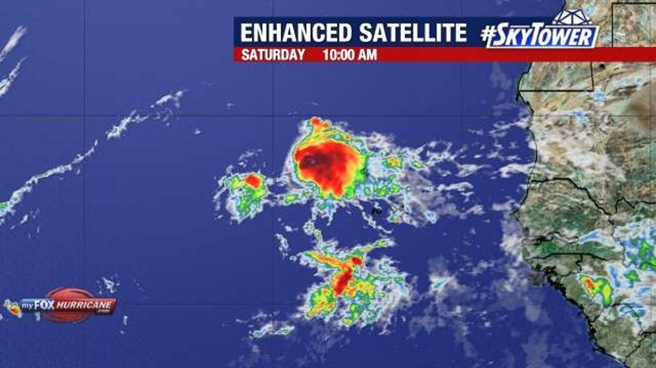
The disturbance is located a couple of hundred miles west of the Cabo Verde Islands. It's now over open water beginning a long journey west across the Atlantic.
What is the forecast for Invest 94L?
The storm became slightly better organized Saturday morning, but still overall lacks enough organization of its thunderstorm activity to be considered a tropical depression or tropical storm, the NHC said.
READ: Power outage tracker: How many Tampa Bay area residents are still in the dark?
Conditions remain favorable for some development Saturday – enough that the storm could become designated as Tropical Depression 15 or even Tropical Storm Nadine later in the day. However, chances for additional development wane later Saturday as the storm moves west into atmospheric conditions that becomes less conducive.
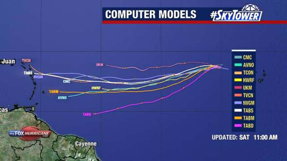
At that point, the disturbance is expected to hold steady without further development through at least the middle of the workweek. After that, forecasters will keep a close eye on the storm as it begins to approach the eastern fringes of the Caribbean.
"So you can see where these models take it generally kind of dip it toward the south as it continues on that westward path, where maybe this starts to impact parts of the Caribbean islands, the Leeward Islands with some rain and some bigger surf," explained FOX 13 News Meteorologist Valerie Mills.
FOXWeather.com contributed to this story.
STAY CONNECTED WITH FOX 13 TAMPA:
- Download the FOX Local app for your smart TV
- Download the FOX 13 News app for breaking news alerts, latest headlines
- Download the SkyTower Radar app
- Sign up for FOX 13’s daily newsletter